Day 11: Travel by train & bus to Rodi & walk to Faido. Travel by train to Lavorgo & walk to Giornico. Travel by bus & train to Bellinzona (MAPS 3 & 4).
After breakfast they headed to the railway station of Airolo (1141m a.s.l.), which is the highest railway station of the Swiss Federal Railways (SBB) (BAHNHOF AIROLO). There they boarded the "Treno Gottardo" to Faido. In Faido they changed to a bus and got off at Rodi "Dazio Grande".
The "Dazio Grande" is a building from the middle of the 16th century. It served as customs house for goods, transit traffic, hoarse-changing station, guesthouse, hostel and warehouse until 1803, the year when the Ticino became part of the Swiss Confederation. It remained in operation, until the Gotthard railway line was inaugurated in 1882. Nowadays, it is still open for the public as a museum and provides a rustic restaurant and overnight accommodation (DAZIO GRANDE).
From there they started their hiking, which took them along the "Via Gottardo Süd", passing by the two most impressive gorges ("Piottino" and "Biaschina"), which are shaping the landscape of the upper Ticino, and ending by the village Giornico.
Day 11: Travel by train & bus to Rodi & walk to Faido. Travel by train to Lavorgo & walk to Giornico. Travel by bus & train to Bellinzona (MAPS 3 & 4).

Figure 97: Voralpen-Express crossing the bridge between Rapperswil and Pfäffikon SZ

Figure 98: View to the "Holzbrücke" wooden bridge, taken from the Voralpen-Express between Rapperswil and Pfäffikon SZ

Figure 99: Einsiedeln with the monastery and the ski jumps

Figure 100: The "Klosterwald" forest of Einsiedeln covered with snow

Figure 101: View from the "Friherrenberg" to the "Sihlsee" lake and the snow-covered eastern-Central Swiss Alps

Figure 102: From the viewing point "Vogelhärd" (975m a.s.l.)
Left picture: A view to Einsiedeln
Right picture: The frozen "Sihlsee" lake

Figure 103: Popular winter hiking and cross-country skiing area near Einsiedeln.
Left picture: Shows the small village of Studen
Right picture: A hiking path near the village of Unteriberg

Figure 104: Alpine panorama view from the hiking track between Einsiedeln and Biberbrugg with the parly frozen "Sihlsee" lake in the back

Figure 105: The town of Einsiedeln surrounded by the Prealps and the eastern-Central Swiss Alps, from a viewpoint at "Schnabelsberg" (950m a.s.l)

Figure 106: Hiking track from Biberbrugg direction Rothenthurm

Figure 107: The Voralpen-Express shortly after leaving the station of Biberbrugg heading direction Rothenthurm

Figure 108: The hamlet "Dritte Altmatt" is a popular place for winter hiking through the moorlands of Rothenthurm, where one can experience the peace of nature.
In the 1980ties the Swiss Armed Forces wanted to make a military training area in Altmatt, however the project was disputed and therefore never realized.
Left picture: Winter hiking trail direction to Rothenthurm
Right picture: The Voralpen-Express traversing along the winter hiking trail

Figure 109: The Voralpen-Express passing along the winter hiking track near Rothenthurm

Figure 110: The moorlands of Rothenthurm which is in winter a popular place for cross-country skiing, winter hiking and horse carriage ride

Figure 111: The compacted snow of the cross-country ski trails in Rothenthurm shaped into characteristic loops

Figure 112: The area between Rothenthurm and the village Biberegg is also a nice place to discover in winter.
Left picture: Winter hiking path along the "Biber" stream, wild and romantic.
Right picture: The skiing place "Biberegg-Neusell" has only two ski lifts, therefore not overcrowded and pleasant for skiing.

Figure 113: The Voralpen-Express passing through the village of Biberegg

Figure 114: The Voralpen-Express entering the village of Sattel. A View to the marvelous alpine panorama of the peaks "Hoflue" (1699m a.s.l.), way in the back "Uri Rotstock" (2929m a.s.l.) and "Brunnistock" (2952m a.s.l.).

Figure 115: View to the snowcapped peak of the "Rigi" mountain from the village of Steinerberg

Figure 116: Panoramic view from the Rigi mountain top "Kulm"

Figure 117: The "Lauerzersee-Sägel-Schutt" nature reserve in its winter dress.
Left picture: The "Goldseeli" lake.
Right picture: Pond imbedded in the marvelous snow-covered landscape of the deposit area of the historic landslide event "Goldauer Bergsturz".

Figure 118: Winter hiking trail in Schwyz with view to the peaks "Gross Mythen" (1898m a.s.l.) and "Klein Mythen" (1811m a.s.l.)

Figure 119: Popular winter, snowshoe hiking and ski resort at the "Stoos" (1313m a.s.l.) above the "Urnersee" lake

Figure 120: The recreation area of the "Reussdelta" near Flüelen covered with snow

Figure 121: An avalanche covering the hiking trail "Via Gottardo" near Amsteg

Figure 122: The village of Wassen with its famous church "Chileli" (taken from the Treno Gottardo shortly after the "Leggistein" turnaround tunnel)

Figure 123: The village of Göschenen covered with snow. In the front we can see a self-made snow tower

Figure 124: The amazing landscape of the "Schöllenenschlucht" and the "Teufelsbrücke" bridge covered with ice blocks. I took the picture from the "Matterhorn-Gotthardbahn" driving through to Göschenen from Andermatt.

Figure 125: Panoramic view from the location "Nätschen" (above Andermatt) to the "Urseren" valley

Figure 126: Winter hike from Andermatt to Hospental.
Left picture: The partly frozen "Reuss" river with view to the snow-covered mountains direction to the "Furka" pass.
Right picture: The village of Hospental with the impressive tower block.

Figure 127: The Walser settlement "Zumdorf", which is, with 4 permanent inhabitants, the smallest village in Switzerland.

Figure 128: Hotel "St. Gotthard" in Hospental a charming overnight stay in winter
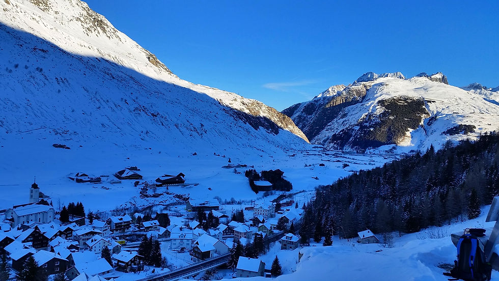
Figure 129: View to Hospental and the "Urseren" valley up to Andermatt

Figure 130: Winter hiking tour from Hospental to "Gamsboden" (direction to the Gotthard pass). During summer this road is used by cars and postbusses. In winter one can enjoy the tranquillity of the landscape surrounding the Gotthard massif.

Figure 131: The area between the location "Motto Bartola" (1528m a.s.l.) and the Gotthard pass is in winter very peaceful. One can enjoy nature's beauty and experience wildlife.

Figure 132: Hiking path from Airolo direction to the Gotthard pass, passing first through a marvelous snow covered pine forest (left picture), then follows an alpine path with a panoramic view to the "Alta Leventina" valley (right picture)

Figure 133: View from the descend at "Motto Bartola" (1528m a.s.l.) to Airolo. We can see the "Alta Leventina" valley with the "Treno Gottardo" just exiting the Gotthard tunnel (bottom of picture). On the upper part of the picture we can see the "Alpe di Pesciüm" (1800m a.s.l.), which is one of the most popular ski resorts in the Ticino.

Figure 134: The location "Culisio" (1520m a.s.l.) between Airolo and the "Alpe di Pescüm"

Figure 135: The location "Motto Bartola" (1528m a.s.l.) between Airolo and the Gotthard pass after a snowstorm

Figure 136: Warm up with a delicious cappuccino and "Amaretti" biscuit in the Treno Gottardo

Figure 137: The "Bedretto" valley is the upper foothill of the "Leventina" valley and streaches from Airolo, at the foot of the Gotthard pass, up to the Nufenen pass. it is a popular place for winter hiking, snowshoe hiking and ski tours.
The left picture shows the small uninhabitated village Albinasca with view to the upper "Leventina" valley, the right picture, the small village Fontana with view to the "Bedretto" valley.

Figure 138: The "Val Canaria" is a peaceful side valley, east of Airolo. It is a popular place in winter for hiking and snowshoe hiking.

Figure 139: Treno Gottardo leaving Airolo and view to Switzerland's snow castle: the mountains of the Gotthard region

Figure 140: The village of Brugnasco, which can be reached through the panoramic "Strada alta" alpine path from Airolo

Figure 141: The hiking track "Via Gottardo" from Airolo to Piotta.
One can admire several rocks covered with impressive ice sculptures, in the close proximity to the location of the power station "Stalvedro".

Figure 142: Treno Gottardo between Ambri-Piotta and Airolo with view to the snow-covered Gotthard massif

Figure 143: The "Sanatorio del Gottardo", build in the year 1905, is a pompous building imbedded into a wonderful nature, just above the village of Piotta and used to be a health resort for tuberculosis patients, especially during World War II. In 1962 the building had to close down as the disease had been eradicated. Since 60 years the building remained empty and is one of the longest abandoned buildings in Switzerland.

Figure 144: The "Alta Leventina" between the villages of Piotta and Ambri shows a wide valley.
The left picture has been taken from the village Deggio above Quinto and shows the settlement area of Ambri, Piotta and way in the back the snow-coverd mountains of the Gotthard massif.
The right picture has been taken in the valley from the village of Ambri and shows the Treno Gottardo heading direction to Airolo.

Figure 145: Three villages in the "Alta Leventina":
Ambri Quinto Deggio

Figure 146: Treno Gottardo between Ambri-Piotta and Faido, shortly before the village of Rodi

Figure 147: The "Piottino" gorge is also during the winter an interesting place to visit.
Left picture: the gorge. Right picture: Treno Gottardo traversing the gorge.

Figure 148: View from the "Via Gottardo" hiking track from Faido to the "Piottino" gorge. As you can see, in the bottom of the picture, squeezed between the trees, the Treno Gottardo just heading to the "Prato" helical tunnel.

Figure 149: Treno Gottardo shortly before arriving at the station of Faido. View to the eastern valley side of the "Media Leventina" with the villages Mairengo and Osco.

Figure 150: View to the "Media Leventina" valley direction south, taken from the location "Fontané" along the "Strada alta" alpine path. The picture shows on the left side the village of Fusnengo. On the far right is the snow-covered peak of the "Pizzo Forno" (2907m a.s.l.).
_corr.jpg)
Figure 151: Sunrise over the village of Mairengo above Faido
_corr.jpg)
Figure 152: The village of Primadengo above Faido

Figure 153: View to the "Media Leventina" valley direction north with the villages of Calpiogna and Osco. Way in the back is Switzerland's snow castle the "Gotthard" region

Figure 154: The village of Faido under the snow

Figure 155: "Piumogna" waterfall in Faido.
Left picture: The icicles falling off the rocks show an imposing ice sculpture.
Right picture: Snow covering the ice sculpture.

Figure 156: The brewery of the "Gottardo" beer in Faido, which keeps up till now the old German brewing tradition (ingredients, fermentation and ripening process) since the year 1516

Figure 157: View to the village of Faido taken from the hiking track direction to Gribbio

Figure 158: "Rustico" house in the hamlet Chinchengo near Faido (left picture) and at the location "Raslönciö" near Lavorgo (right picture)

Figure 159: The village of Calonico (above Lavorgo) is famous for its little church "San Martino", which stands isolated on a spur of rock high above the "Media Leventina" valley.
Left picture: The "San Martino" church, which probably dates back to the 12th century.
Right picture: The "San Martino" church and view to Faido and the "Media Leventina" valley.

Figure 160: Winter hiking trail along the "Via Gottardo" to Chironico

Figure 161: The village of Chironico and view to the snow-coverd peaks, from left to right: the "Pizzo del Sole" (2773m a.s.l.), "Pizzo di Campello" (2660m a.s.l.) and "Pizzo Molare" (2585m a.s.l.)

Figure 162: The village of Giornico in the deepest winter

Figure 163: View from the "Castelgrande" castle to the city of Bellinzona with the surrounding snow covered peaks of the "Pizzo di Claro" (2727m a.s.l.) and "Torrone Rosso" (2669m a.s.l.)

Figure 164: The old town of Bellinzona with way back the castles "Montebello" and "Sasso Corbaro" coverd with snow

Figure 165: The Saturday market in the "Piazza Collegiata" Bellinzona
Left picture: During Christmas time
Right picture: During Carnival

Figure 166: Castle "Montebello" in Bellinzona

Figure 167: Walk along the crenelled wall of the castle "Montebello" in Bellinzona.
Left picture: View to the city of Bellinzona and way in the back the "Magadino" plains.
Right picture: "Treno Gottardo" exiting the tunnel under the crenelled wall of the "Montebello" castle.

Figure 168: Ice surfaces covering the lagoon areas of the "Bolle di Magadino" nature reserve

Figure 169: Viewpoint from the village Brione s. Minusio.
Left picture: "Bolle di Magadino" and "Magadino" plane.
Right picture: "Maggia" delta with the "Brissago" islands

Figure 170: The winterstorm "Antonia" on the 21th of February 2022 close to Locarno.
Left picture: View to the city of Locarno and the upcoming storm
Middle picture: Camellia bushes and view to the "Madonna del Sasso" church, under the storm coming to its end
Right picture: View to the "Bolle di Magadino" after the storm

Figure 171: The flow of "Maggia" river in its estuary showing low water level in winter

Figure 172: Locarno's "Parco della Pace" park is also in winter a peaceful place to enjoy


Figure 173: Three photo captures showing the beautiful lagoon landscape of the very end of the "Maggia" delta and the "Lago Maggiore" lake

Figure 174: Ascona still keeps it's Mediterranean charm even during winter.
Left picture: View to the village of Ascona from the hiking path direction to the "Monte Verità" (332m a.s.l.).
Right picture: View to the "Lago Maggiore"lake from the harbor of Ascona.

Figure 175: Sun terrace of the "gelateria l'Angolo dei Golosi", also in winter a lovely place to enjoy

Figure 176: Feathered bathers enjoying the beach in Minusio

Figure 177: Relaxing place in Minusio, close to Locarno, where in the peak of winter one can experience summer feelings!

Figure 178: Close to the village of Contra (above Tenero) one can reach the dam of the "Verzasca" river, which is with a height of 220 meters belonging to the highest dam in Europe. In January 2022 the artificial lake "Lago di Vogorno" in the "Verzasca" valley was emptied for the first time since 56 years due to remediation work at the lake bottom. Therefore one can see traces of the former terraced vineyards of Vogorno.