Day 11: Travel by train & bus to Rodi & walk to Faido. Travel by train to Lavorgo & walk to Giornico. Travel by bus & train to Bellinzona (MAPS 3 & 4).
After breakfast they headed to the railway station of Airolo (1141m a.s.l.), which is the highest railway station of the Swiss Federal Railways (SBB) (BAHNHOF AIROLO). There they boarded the "Treno Gottardo" to Faido. In Faido they changed to a bus and got off at Rodi "Dazio Grande".
The "Dazio Grande" is a building from the middle of the 16th century. It served as customs house for goods, transit traffic, hoarse-changing station, guesthouse, hostel and warehouse until 1803, the year when the Ticino became part of the Swiss Confederation. It remained in operation, until the Gotthard railway line was inaugurated in 1882. Nowadays, it is still open for the public as a museum and provides a rustic restaurant and overnight accommodation (DAZIO GRANDE).
From there they started their hiking, which took them along the "Via Gottardo Süd", passing by the two most impressive gorges ("Piottino" and "Biaschina"), which are shaping the landscape of the upper Ticino, and ending by the village Giornico.
Day 11: Travel by train & bus to Rodi & walk to Faido. Travel by train to Lavorgo & walk to Giornico. Travel by bus & train to Bellinzona (MAPS 3 & 4).
Day 5: Travel to Seelisberg by train, boat & cable railway via Brunnen. Walk from there to the "Rütli" harbor via "Rütliwiese". Continue by boat to Sisikon and walk to Flüelen (Map 2).
After an early breakfast they headed to the railway station to check-in their luggage to their next overnight stop in Flüelen. Then they boarded their train to Brunnen. The village of Brunnen is part of the community Ingenbohl (approx. 9000 inhabitants) which also includes the settlements Unterschönenbuch and Wylen. The birth of the Swiss Confederation started in the former fishing village of Brunnen and the area of the "Urnersee" Lake (BRUNNEN).
In Brunnen they had a good hour until their boat to "Treib" would depart. On their way to the harbor they passed by the confectionery "Schelbert" and enjoyed an original specialty "Muotathaler Rahmkirschtorte" (MUOTATHALER RAHMKIRSCHTORTE). The "Muotathal" is a valley near Brunnen, where a group of weather prophets meet to forecast the yearly seasonal weather for the whole of Switzerland (MUOTATHAL).
The boat crossing from Brunnen to Treib took them ten minutes. The small harbor of Treib, which is the station of the historic cable railway "Treib-Seelisberg-Bahn" (Figure 19, left picture) is an important connection to the village of Seelisberg. It has celebrated in 2016 it's 100 years anniversary. They experienced a very special trip with the old cable railway car which was well kept. The small village of Seelisberg (850m a.s.l.) has a population of about 700 inhabitants and is named the sun terrace of the Lake of Lucerne (SEELISBERG).

Figure 19: Historic cable railway "Treib-Seelisberg-Bahn", bottom station (left picture) and top station (right picture)
At the top station (Figure 19, right picture) of the cable railway they enjoyed the warmth of the sun, the beautiful view to the "Urnersee" Lake and the surrounding peaks of the Central Swiss Alps. Nearby they found a small pick nick place (Figure 20).

Figure 20: View from Seelisberg to the "Urnersee" lake and the Central Swiss Alps
Half an hour later they headed to the "Rütliwiese", following a small path, which is part of the "Weg der Schweiz" trail. The "Weg der Schweiz" (Swiss Path) was founded in the year 1991 on the occasion of the 700 year anniversary of the birth of the Swiss Confederation. It includes a total of 35km hiking trail around the southern part of the Lake Lucerne (Urnersee). The hiking trail starts at the "Rütli" and ends in Brunnen. Each canton has been assigned a section of the hiking trail (WEG DER SCHWEIZ).
Their way to the "Rütliwiese" went through the forest reserve "Rütliwald" (Figure 21), which belongs to the first protected forest reserve in Canton Uri. It harbors several rare and protective forest communities and shows a wide biodiversity (RÜTLIWALD).

Figure 21: Hiking track through the forest reserve "Rütliwald"
The "Rütliwiese" (Figure 22) is the location were the pact of alliance "Rütlischwur" between the three founding cantons: Schwyz, Uri and Unterwalden (nowadays divided into Obwalden and Nidwalden), was sworn in the year 1291 and is of national importance (RÜTLI).

Figure 22: "Rütliwiese"
From the "Rütliwiese" they walked down to the harbor "Rütli", following a small passage through the forest reserve "Rütliwald".
From the harbour they boarded the steam boat "Uri" (Figure 23, left picture), which is the oldest steam boat in Switzerland built in 1901, to Sisikon (DAMPFSCHIFF URI). The crossing took them 10min.

Figure 23: Boat trip to Sisikon (right picture) with steam boat "Uri" (left picture)
From Sisikon they walked further another part of the "Weg der Schweiz" trail up to Flüelen. First on the way came the "Tellskapelle"
(Figure 24), where they made a short break. The chapel was build in the year 1879/80. It has impressive fresco paintings by Ernst Stückelberg (Figure 24; right picture) and it also is said to be the place where Wilhelm Tell (the national Swiss hero) took refuge by jumping from the boat where he was taken prisoner by the provincial governor Gessler (TELLSKAPELLE).

Figure 24: "Tellskapelle" (left picture) and one of the impressive fresco painting by Ernst Stückelberg (right picture) showing the scene, where Wilhelm Tell took refuge by jumping from the boat
After the visit to the small chapel they went to see the famous "Glockenspiel" (Figure 25). It is the biggest "Glockenspiel" (chimes) in Switzerland with 37 bells ringing a great variety of sounds and plays during the day, always the first ten minutes on the hour (GLOCKENSPIEL).

Figure 25: "Glockenspiel" (chimes) near Tellsplatte
Then, they continued their walk to Flüelen (approx. 4km) along the "Axenstrasse" road, which was surrounded by steep and massive rock walls (Figure 26). The trail went partly through small pedestrian tunnels.
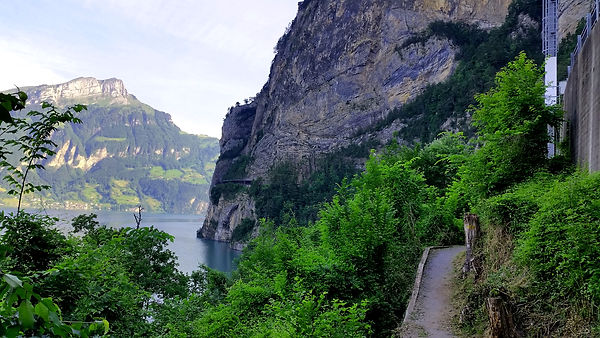
Figure 26: Hiking track along the "Axenstrasse"
When they reached their destination Flüelen, they went to the lido and had a short break. From there they continued to the guesthouse "Vögeliwohl", which was located close to the railway station in the centre of Flüelen. The friendly and warm approach impressed everybody and lived up to the guesthouse's name. They looked forward to their stay for the coming two nights. For dinner they went to the restaurant "MIXX", which had a beautiful terrace overlooking the "Urnersee" lake.