Day 11: Travel by train & bus to Rodi & walk to Faido. Travel by train to Lavorgo & walk to Giornico. Travel by bus & train to Bellinzona (MAPS 3 & 4).
After breakfast they headed to the railway station of Airolo (1141m a.s.l.), which is the highest railway station of the Swiss Federal Railways (SBB) (BAHNHOF AIROLO). There they boarded the "Treno Gottardo" to Faido. In Faido they changed to a bus and got off at Rodi "Dazio Grande".
The "Dazio Grande" is a building from the middle of the 16th century. It served as customs house for goods, transit traffic, hoarse-changing station, guesthouse, hostel and warehouse until 1803, the year when the Ticino became part of the Swiss Confederation. It remained in operation, until the Gotthard railway line was inaugurated in 1882. Nowadays, it is still open for the public as a museum and provides a rustic restaurant and overnight accommodation (DAZIO GRANDE).
From there they started their hiking, which took them along the "Via Gottardo Süd", passing by the two most impressive gorges ("Piottino" and "Biaschina"), which are shaping the landscape of the upper Ticino, and ending by the village Giornico.
Day 11: Travel by train & bus to Rodi & walk to Faido. Travel by train to Lavorgo & walk to Giornico. Travel by bus & train to Bellinzona (MAPS 3 & 4).
Report of excursions using the Voralpen-Express and Treno Gottardo.
Winter was slowly coming to an end. Daniela wanted to start planning for the next excursion. She was thinking of visiting the cantons: Schwyz, Uri and Ticino, using again her favorite way of transport the train, mainly the Voralpen-Express and the Treno Gottardo.
She contacted Thomas, who already assisted her in the last excursion. They agreed to meet beginning April to discuss the program, which Daniela would work on in the mean time.
On a sunny day in April she met Thomas at the café "Rosenstädter" in Rapperswil to discuss the program. Thomas took the program to look it over. Daniela also informed Thomas that Matthias would like to take part in the excursion.
The excursion program comprises the following:
Day 1: Meet in Rapperswil and travel by train via Biberbrugg to Einsiedeln. Visit "Kloster Einsiedeln", walk to "Friherrenberg"
(approx. 2.5km) and from there to "Sihlsee" lake (approx. 2km) and back to Einsiedeln (approx. 3km) (Map 1).
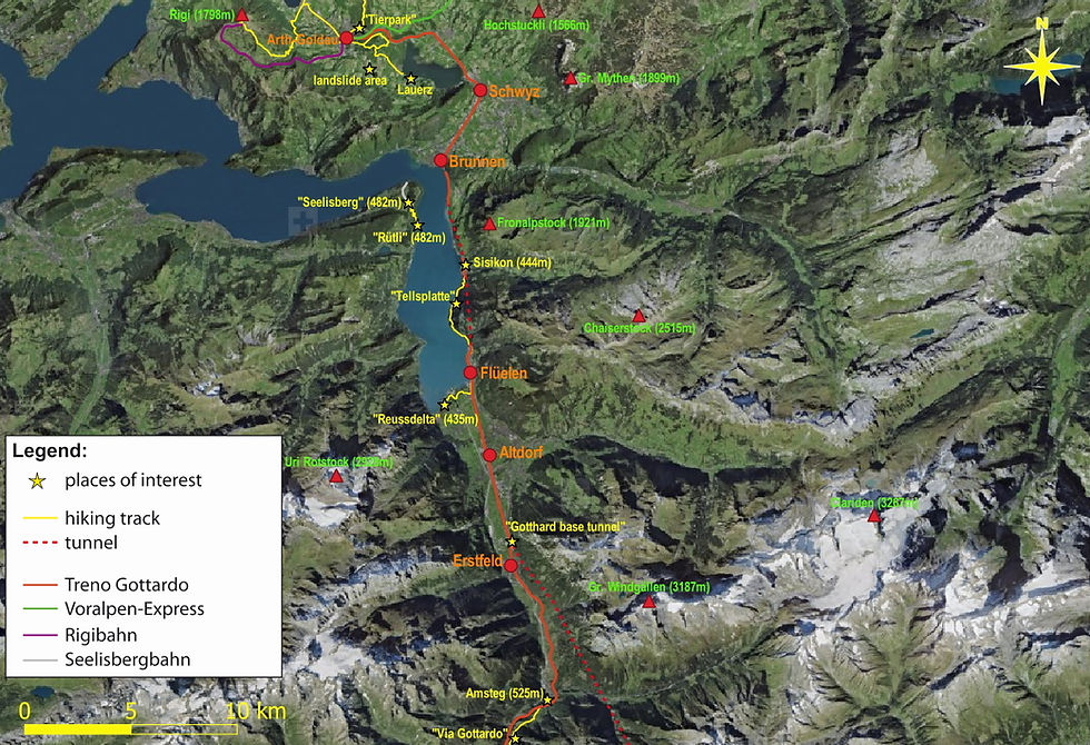
Day 2: Walk from Einsiedeln to Rothenthurm (approx. 17km) and visit the famous "Hochmoor" nature reserve. Continue by train to Arth-Goldau (Map 1).
Day 3: Travel by train to "Rigi Kulm". Walk from there down to Arth (approx. 7.5km) and back to Goldau (approx. 3.5km) (Map 1).
Day 4: Explore the track of the famous historical landslide "Goldauer Bergsturz". Walk from Goldau to Gribsch (approx. 3km), from there to Lauerz (approx. 8.5km) and back to Goldau (approx. 4km) (Map 1).
Day 5: Travel by train to Brunnen, then take a boat to "Treib". From there continue with cable railway to Seelisberg. Next walk to the "Rütli" (approx. 2.5km) and afterwards go by boat to Sisikon.
From there walk to Flüelen (approx. 6.5km) (Map 2).
Day 6: Visit "Reussdelta" near Flüelen (approx. 2.5km) and relax (Map 2).
Day 7: Travel by train to Erstfeld and change to a bus direction to Amsteg. Walk from there along the "Gotthardbahn" railway line to Göschenen (approx. 14km) (Maps 2 & 3).
Day 8: Walk from Göschenen via the "Schöllenenschlucht" to Andermatt (approx. 3.5km) and from there continue to Hospental (approx. 4km) (Map 3).
Day 9: Walk to the Passo del San Gottardo (2106m a.s.l.) (approx. 8km) (Map 3).
Day 10: Walk to Airolo (approx. 6km) (Map 3).
Day 11: Travel by train to Faido and change to a bus direction to Rodi "Dazio Grande". Continue from there by foot along the "Gotthardbahn" railway line to Faido (approx. 4.5km). Travel by train to Lavorgo and walk from Lavorgo to Giornico (approx. 6.5km). Continue further by bus and train to Bellinzona (Maps 3 & 4).
Day 12: Visit Bellinzona & make tour to castles (approx. 6km). From there continue by train and bus to Magadino. Visit the "Bolle di Magadino" wetlands and make a tour through nature reserve (approx. 1km). Spend the rest of the afternoon in Magadino at the lido and continue further to the last destination Locarno by bus and train (Map 4).
Day 13: Visit Locarno and Ascona. Walk to "Madonna del Sasso" (approx. 2km) and continue from there via "Monte della Trinita" back to Locarno "Piazza Grande" (approx. 2km). Take from there a bus to Losone and walk to the "Maggia" estuary (approx. 2.5km), continue from there to Ascona center via "Terreni alla Maggia" farm (approx. 5km) (Map 4).
End of Excursion.

Map 1 (Days 1-4): The SOB-Voralpen-Express train line with hiking tracks (yellow lines) and places of interest (yellow stars)
Source: ©Swisstopo; map modified with QGIS 3.4.1
Map 2 (Days 5-7): The Treno Gottardo (first part) with hiking tracks (yellow lines) and places of interest (yellow stars)
Source: ©Swisstopo; map modified with QGIS 3.4.1

Map 3 (Days 7-11): The Treno Gottardo (second part) with hiking tracks (yellow lines) and places of interest (yellow stars)
Source: ©Swisstopo; map modified with QGIS 3.4.1

Map 4 (Days 11-13): The Treno Gottardo (third part) with hiking tracks (yellow lines) and places of interest (yellow stars)
Source: ©Swisstopo; map modified with QGIS 3.4.1