Day 11: Travel by train & bus to Rodi & walk to Faido. Travel by train to Lavorgo & walk to Giornico. Travel by bus & train to Bellinzona (MAPS 3 & 4).
After breakfast they headed to the railway station of Airolo (1141m a.s.l.), which is the highest railway station of the Swiss Federal Railways (SBB) (BAHNHOF AIROLO). There they boarded the "Treno Gottardo" to Faido. In Faido they changed to a bus and got off at Rodi "Dazio Grande".
The "Dazio Grande" is a building from the middle of the 16th century. It served as customs house for goods, transit traffic, hoarse-changing station, guesthouse, hostel and warehouse until 1803, the year when the Ticino became part of the Swiss Confederation. It remained in operation, until the Gotthard railway line was inaugurated in 1882. Nowadays, it is still open for the public as a museum and provides a rustic restaurant and overnight accommodation (DAZIO GRANDE).
From there they started their hiking, which took them along the "Via Gottardo Süd", passing by the two most impressive gorges ("Piottino" and "Biaschina"), which are shaping the landscape of the upper Ticino, and ending by the village Giornico.
Day 11: Travel by train & bus to Rodi & walk to Faido. Travel by train to Lavorgo & walk to Giornico. Travel by bus & train to Bellinzona (MAPS 3 & 4).
Day 1: Meet in Rapperswil & travel by train to Einsiedeln. Visit "Kloster Einsiedeln", walk to the "Friherrenberg" mountain, the "Sihlsee" lake & back to Einsiedeln (Map 1).
It was a sunny and hot day, End of August, when the 12 participants of the excursion got together at Rapperswil railway station. It was a happy reunion after exactly one year. While Daniela was checking the list of participants, her phone rang and it was Matthias, who had to apologize for not being able to join them because he had to deal with an urgent matter and he promised to join them as soon as possible. So, they all headed to the track nr. 5 and boarded the new copper-colored "Traverso" train of the Voralpen-Express (TRAVERSO), departing Rapperswil at 08:59 and heading direction to Lucerne. The trip to Biberbrugg took them 20min. During the trip they enjoyed a wonderful panorama view of the Lake of Zurich with the islands "Lützelau" and "Ufenau" as well as the prominent promontory of "Hurden" (Figure 1).
In the background they could see the peaks of the "Bachtel" (1115m a.s.l.), "Alp Scheidegg" (1200m a.s.l.), "Säntis" (2502m a.s.l.) and even could recognize the "Lägern Hochwacht" (866m a.s.l.). It reminded them of the last year's excursion. In Biberbrugg they changed to another train to Einsiedeln.
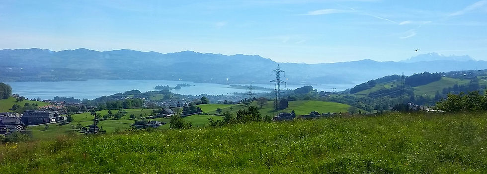
Figure 1: Journey with the Voralpen-Express from Rapperswil to Biberbrugg, with view to Rapperswil, the islands "Lützelau", "Ufenau" and the promontory of "Hurden"
Einsiedeln is a small town and is a famous pilgrimage town, because of its monastery "Kloster Einsiedeln" (Figure 2). The community includes besides Einsiedeln 6 other villages: Bennau, Egg, Willerzell, Euthal, Gross and Trachslau and has a population of about 16'000 inhabitants (EINSIEDELN).
_corr.jpg)
Figure 2: The monastery of Einsiedeln
After arrival in Einsiedeln they checked in their hotel, "Allegro", a small hotel, which is situated between the monastery and the "Sihlsee" Lake. Then they walked to the Benedictine monastery, which has been since centuries an important place for pilgrims. The beginning of pilgrimage in Einsiedeln goes back to the early 9th Century (KLOSTER EINSIEDELN). The church build in the Baroque period impressed them by all the holy decorations which were still well kept in their original colors and shapes.
Next they started hiking to the "Friherrenberg" (1110m a.s.l.), passing through the impressive broad-leaved mixed forest of the "Klosterwald". The approx. 930ha large forest has always been cared for by the monastery. Since the beginning of 2013 the "Oberallmeindkorporation Schwyz (OAK)" took over the management of the forest with the aim of using it under an efficient, cost-effective and sustainable manner and providing a forest with high biodiversity. The monastery, however, still kept the sawmill under its ownership (KLOSTERWALD). On their path there were several information boards, which described the types of trees typical for this forest and their ecological function regarding the forest habitat. When they reached the peak of the "Friherrenberg" they enjoyed their lunch pick-nick with a wonderful panoramic view to the northern Prealps, the Glarus Alps and eastern-Central Swiss Alps as well as the "Sihlsee" Lake
(Figure 3).

Figure 3: View from the "Friherrenberg" to the "Sihlsee" lake and eastern-Central Swiss Alps
The "Sihlsee" Lake with a surface area of 10.85km2 is one of the biggest artificial lake in Switzerland and was made in 1937 by the Swiss Federal Railway (SBB) for the impoundment of water from the "Sihl" river to gain traction power supply. In addition, the water from the lake is also an important source for drinking water. In spite of being an artificial lake, it provides several habitats, which are important for a diverse flora and fauna (SIHLSEE).
It was such a lovely day and everybody was feeling happy to meet again. After lunch Thomas gave them a short information about the evolution of landscape development of the area. The landscape area of the northern Prealps, the northern and eastern-Central Swiss Alps is a product of plate tectonic processes, glacial processes and actual processes (e.g., uplift and denudation of the mountains). It started 200-150mio. years ago in the early Mesozoic, when plate tectonic processes caused that the former supercontinent "Pangäa" got disrupted and disintegrated. Consequently a wide ocean basin called "Tetys" could develop, where important material could deposit on its ground, which are important for main landscape features of Switzerland. The Alps are mountains shaped by folds and covers. These mountains have been produced under high pressure, which were the result of tectonic processes, when the African and European continent collided together in the Mesozoicum. Therefore the Swiss Alps are formed by complex features of crystalline and limestone material, which build the highest peaks of the Swiss landscape (between 3000 and 4000m a.s.l.).
The Prealps have a similar landscape evolution like the midland, they are also shaped out of molasses, which are the result of the debris deposited from the Alps. Because of their nearer proximity to the Alps, the material that got deposited is larger, creating therefore higher mountains of approximately 1500m a.s.l. (PREALPINE & ALPINE LANDSCAPE DEVELOPMENT).
Leaving the "Friherrenberg" they went to the "Sihlsee" lake, where they spend the rest of the afternoon. On the way they could see the largest artificial ski jump construction in Switzerland, the "Einsiedler Sprungschanze" (Figure 4). Ski jumps are regularly used for training by several top athletes, local (such as, Simon Amman, Andreas Küttel) and from all over the world (SCHANZENEINSIEDELN).
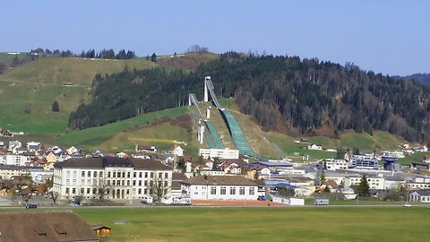
Figure 4: Ski jumps "Einsiedler Sprungschanzen"
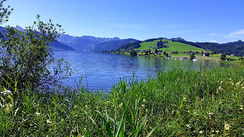
Figure 5: "Sihlsee" lake
After a refreshing swim in the lake (Figure 5) it was dinner time and they decided to eat dinner in the hotel. Later, Daniela gave the group a short briefing for the next day before retiring to bed.