Day 11: Travel by train & bus to Rodi & walk to Faido. Travel by train to Lavorgo & walk to Giornico. Travel by bus & train to Bellinzona (MAPS 3 & 4).
After breakfast they headed to the railway station of Airolo (1141m a.s.l.), which is the highest railway station of the Swiss Federal Railways (SBB) (BAHNHOF AIROLO). There they boarded the "Treno Gottardo" to Faido. In Faido they changed to a bus and got off at Rodi "Dazio Grande".
The "Dazio Grande" is a building from the middle of the 16th century. It served as customs house for goods, transit traffic, hoarse-changing station, guesthouse, hostel and warehouse until 1803, the year when the Ticino became part of the Swiss Confederation. It remained in operation, until the Gotthard railway line was inaugurated in 1882. Nowadays, it is still open for the public as a museum and provides a rustic restaurant and overnight accommodation (DAZIO GRANDE).
From there they started their hiking, which took them along the "Via Gottardo Süd", passing by the two most impressive gorges ("Piottino" and "Biaschina"), which are shaping the landscape of the upper Ticino, and ending by the village Giornico.
Day 11: Travel by train & bus to Rodi & walk to Faido. Travel by train to Lavorgo & walk to Giornico. Travel by bus & train to Bellinzona (MAPS 3 & 4).
S15 train line:
Train route:

Figure 1: S15 train "Regio Dosto" at the railway station of Niederweningen

Figure 2: S15 train with the "Lägern" mountain chain in the back, passing the small village Sünikon (between Schöfflisdorf-Oberweningen and Steinmaur)

Figure 3: S15 train in Sünikon with view to the village of Regensberg

Figure 4: S15 train between Dielsdorf and Niederhasli

Figure 5: S15 train approaching the "Ritterhaus" of Bubikon

Figure 6: S15 train leaving Rüti

Figure 7: S15 train traversing the forest between Rüti and Jona

Figure 8: S15 train entering Rapperswil-Jona
Extra pictures:

Figure 9: Village of Niederweningen

Figure 10: Swimming pool "Sandhöhli" in Niederweningen

Figure 11: View from Regensberg

Figure 12: Regensberg village center

Figure 13: View to the easternmost foothills of the "Faltenjua" mountain from a pond near the train station "Steinmaur"

Figure 14: "Mettmenhaslisee" lake in Niederhasli by sunrise

Figure 15: Hiking track from Uster to Seegräben with wonderful alpine panoramic view

Figure 16: Village center of Seegräben

Figure 17: "Pfäffikersee" lake from the village of Seegräben with the city of Wetzikon in the background

Figure 18: Water lilies growing in the "Egelsee" lake in Bubikon

Figure 19: Golf course along the hiking track from Bubikon to Rüti

Figure 20: Hiking track from Fischental to the "Alp Scheidegg"

Figure 21: Forest under nature conservation between Rüti and Jona
Figure 22: View from Rapperswil to the islands of "Lützelau" and "Ufenau"

Figure 23: Boat crossing from Rapperswil to the island of "Ufenau"

Figure 24: Arrival of the boat at the island of "Ufenau"

Figure 25: "Holzbrücke" bridge from Rapperswil to Hurden. One can see several small islands along the walk over the bridge, which are an important breeding place for birds.

Figure 26: Mallard ducs waddeling along the Rapperswil lake promenade by the castle
The Voralpen-Express train and Treno Gottardo:
Train route:

Figure 27: "Traverso" train of the Voralpen-Express at Rapperswil railway station

Figure 28: "Voralpen-Express" crossing the dam of "Hurden" from Rapperswil to Pfäffikon SZ
Figure 29: "Voralpen-Express" with view to the Lake of Zurich, in the background the islands of "Ufenau" and "Lützelau"

Figure 30: "Voralpen-Express" heading to Biberbrugg, passing along some vineyards near Wollerau

Figure 31: "Voralpen-Express" passing through the moorlands of "Rothenthurm"

Figure 32: "Treno Gottardo" in Flüelen and view to the "Reussdelta" nature reserve in the back

Figure 33: "Treno Gottardo" passing by Silenen and view to the snow-covered peak of the "Bristen" mountain

Figure 34: "Treno Gottardo" at Amsteg traversing the "Kerstelenbachbrücke" bridge

Figure 35: "Treno Gottardo" traversing the "Intschireuss" bridge

Figure 36: "Treno Gottardo" at Wassen with view to the famous church of Wassen "Chileli"

Figure 37: "Treno Gottardo" at Wassen heading to Göschenen

Figure 38: "Treno Gottardo" at Göschenen passing by one of the cable booth "Kabelbude"

Figure 39: "Treno Gottardo" at Göschenen approaching the entrance to the Gotthard tunnel

Figure 40: "Treno Gottardo" coming out of the Gotthard tunnel in Airolo with view to the upper "Leventina" valley in the background

Figure 41: "Treno Gottardo" with view to the village of Airolo and the road to the Gotthard pass

Figure 42: "Treno Gottardo" in Faido

Figure 43: "Treno Gottardo" between Faido and Lavorgo and way to the back stands the little church of "San Martino" in Calonico

Figure 44: "Treno Gottardo" traversing over a bridge on the line between Faido and Lavorgo

Figure 45: "Treno Gottardo" passing by the village of Chiggiogna and view to the waterfall of Calonico

Figure 46: "Treno Gottardo" in Lavorgo with view to the middle part of the "Leventina" valley

Figure 47: "Treno Gottardo" in Giornico, passing by the old church "San Nicola" from the 12th century and view to the lower part of the "Leventina" valley

Figure 48: "Treno Gottardo" leaving Bellinzona with view to the castle "Castelgrande" and the defense wall of the "Montebello" castle on the right side

Figure 49: "Treno Gottardo" approaching it's final destination Locarno

Figure 50: "Traverso" train of the "Treno Gottardo" at Locarno railway station
Extra pictures:

Figure 51: "Klosterwald" forest in Einsiedeln

Figure 52: The moorlands of Rothenthurm

Figure 53: Hotel "Rössli" in Goldau with the "Rossberg" mountain in the background, the place where the historical landslide event "Goldauer Bergsturz" took place in 1806

Figure 54: View to the "Rigi" mountain from the village of Arth

Figure 55: The popular leisure area "Tierpark Goldau"

Figure 56: Special forest reserve "Sonderwaldreservat Goldauer Bergsturz"

Figure 57: Hiking track through the deposition area of the historical landslide event "Goldauer Bergsturz"

Figure 58: "Lauerzersee" lake and view to the "Mythen" mountains

Figure 59: Boat crossing from Brunnen to Treib and view to the mountain peaks of the "Bristen" (far left) and "Uri Rotstock" (far right)

Figure 60: Picture of the chapel "Tellskapelle" taken from the boat on the "Urnersee" lake

Figure 61: Hiking track between Sisikon and Flüelen going parly through small pedestrian tunnels

Figure 62: Guesthouse "Vögeliwohl" located in the heart of the village of Flüelen

Figure 63: Picture taken from the "Fellibrücke" hanging bridge of the "Reuss" river

Figure 64: Artificial lake of the hydroelectric power station "Wassen", way back view to the famous church "Chileli" of Wassen
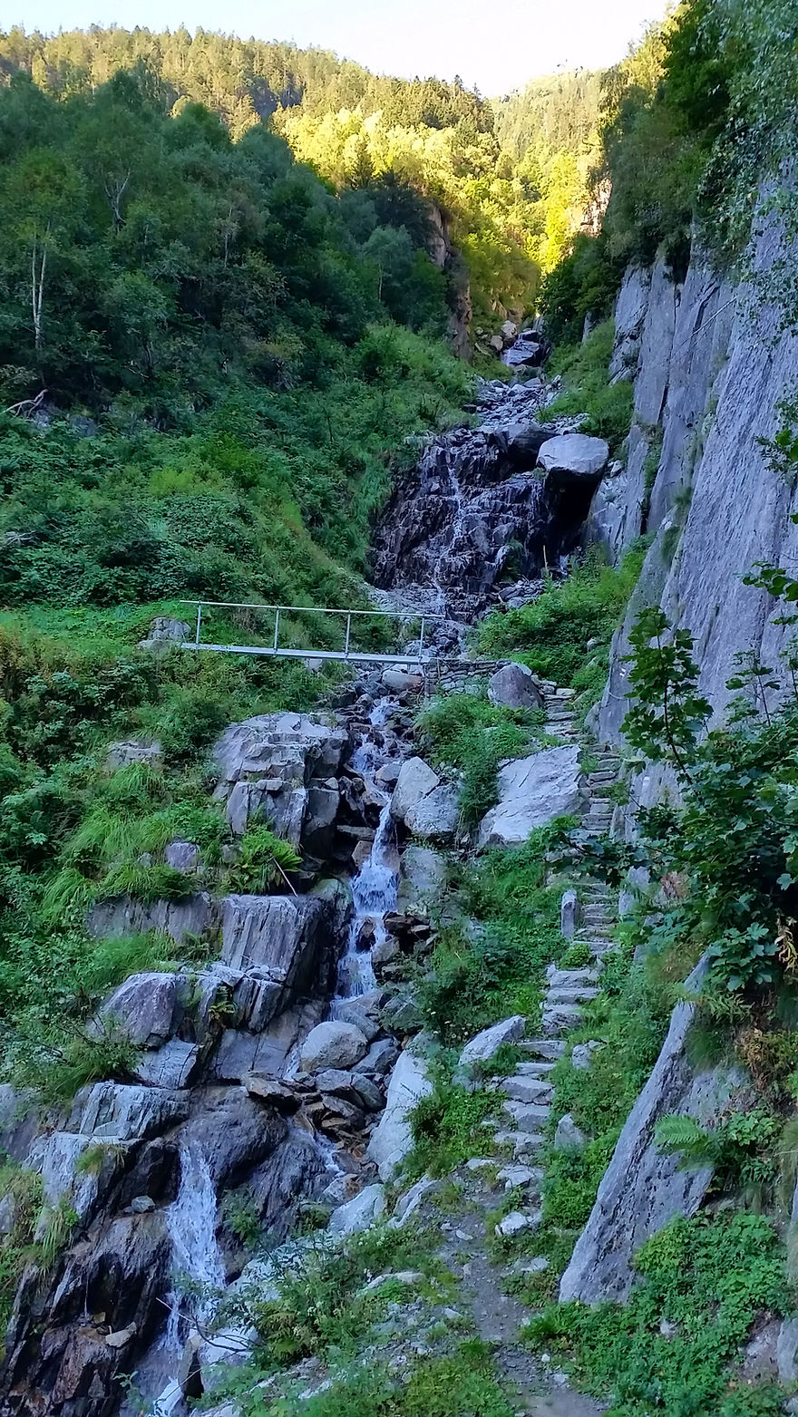
Figure 65: Hiking track between Wassen and Göschenen

Figure 66: Former survey adit (Visierstollen) used for the construction of the Gotthard railway tunnel

Figure 67: Hotel "Zum Weissen Rössli" in Göschenen

Figure 68: On the right side hiking track through the "Urnerloch" tunnel from the "Teufelsbrücke" bridge to Andermatt

Figure 69: Hiking path approaching the Gotthard pass, at aprox. 2000 m a.s.l., with dwarfed larch trees
(Larix decidua)

Figure 70: "Nardus stricta"-alpine grassland near the Gotthard pass, approx. 2000 m a.s.l., with lots of flowering plants especially orchids, e.g. Dactylorhiza maculata

Figure 71: "Ospizio Albergo San Gottardo" on the Gotthard pass

Figure 72: Hiking track from the Gotthard pass to Airolo

Figure 73: "Producers" of the "Gottardo" cheese near the show dairy "Caseificio del Gottardo"

Figure 74: "Dazio Grande" building in Rodi (former customs station between Swiss and Milanese territory)

Figure 75: I was standing in the ice cold water tumbling down from the "Piumogna" waterfall in Faido

Figure 76: Hiking track to Chironico through the chestnut forest "Selva castanile di Nivo"

Figure 77: Chestnut fruit in the "Selva castanile di Nivo" forest

Figure 78: View to the "Bassa Leventina" valley on the hiking track from Chironico to Giornico

Figure 79: Hiking track to Giornico through the area of postglacial-prehistoric landslide "Biaschina"

Figure 80: The village of Giornico with it's old church "San Nicola" from the 12th century

Figure 81: Hostel "Ostello Montebello" in Bellinzona with the crenelled wall of the "Castello di Montebello" castle on the upper left side of the picture

Figure 82: Market stall with delicious "Amaretti" biscuits in the Saturday's market of Bellinzona

Figure 83: Walk along the crenelled walls of the "Castelgrande" castle in Bellinzona

Figure 84: Trachycarpus fortuneii palm tree (Ticino palm tree) growing near the "Montebello" castle in Bellinzona

Figure 85: "Montebello" castle with view to the "Magadino" plain and "Lago Magiore" lake in the background

Figure 86: "Sasso Corbaro" castle in Bellinzona

Figure 87: Outdoor area of the "Ristorante Peverelli", which is located in the heart of the "Piazza Collegiata" in Bellinzona

Figure 88: View to the "Bolle di Magadino" weltands and "Lago Maggiore" lake from the village of Magadino

Figure 89: Estuary area of the "Ticino" river

Figure 90: "San Francesco" church in Locarno

Figure 91: Walk through the narrow streets of the oldtown in Locarno

Figure 92: Vegetation diversity with several thermophilous plant species growing near the "Madonna del Sasso" church

Figure 93: Citrus fruit in Locarno

Figure 94: Cactus fruit in Locarno

Figure 95: Agave growing piercing through a fence wall of a villa in Locarno

Figure 96: Estuary of the "Maggia" river from the Locarno side

Figure 97: Estuary of the "Maggia" river from the Ascona side

Figure 98: Walk through the narrow streets of the historic village center in Ascona

Figure 99: The "Brissago" islands from a viewpoint in Ronco

Figure 100: Vegetation on the "Brissago" islands

Figure 101: From a viewpoint in Ronco, the "Maggia" delta and "Maggadino" plain in the background

Figure 102: Sparrows enjoying a piece of pizza in Locarno

Figure 103: A swarm of mallard ducs and pigeons invading the "Parco della Pace" parc in Locarno