Day 11: Travel by train & bus to Rodi & walk to Faido. Travel by train to Lavorgo & walk to Giornico. Travel by bus & train to Bellinzona (MAPS 3 & 4).
After breakfast they headed to the railway station of Airolo (1141m a.s.l.), which is the highest railway station of the Swiss Federal Railways (SBB) (BAHNHOF AIROLO). There they boarded the "Treno Gottardo" to Faido. In Faido they changed to a bus and got off at Rodi "Dazio Grande".
The "Dazio Grande" is a building from the middle of the 16th century. It served as customs house for goods, transit traffic, hoarse-changing station, guesthouse, hostel and warehouse until 1803, the year when the Ticino became part of the Swiss Confederation. It remained in operation, until the Gotthard railway line was inaugurated in 1882. Nowadays, it is still open for the public as a museum and provides a rustic restaurant and overnight accommodation (DAZIO GRANDE).
From there they started their hiking, which took them along the "Via Gottardo Süd", passing by the two most impressive gorges ("Piottino" and "Biaschina"), which are shaping the landscape of the upper Ticino, and ending by the village Giornico.
Day 11: Travel by train & bus to Rodi & walk to Faido. Travel by train to Lavorgo & walk to Giornico. Travel by bus & train to Bellinzona (MAPS 3 & 4).
Day 7: Travel by train & bus to Amsteg & walk to Göschenen via Wassen (Maps 2 & 3).
For today they had a long program ahead, so they had an early breakfast and boarded the Treno Gottardo train to Erstfeld.
The "Gotthard railway line" has always been an important railway line for Switzerland since more than 130 years. On the 1th of June 1882 the railway line was inaugurated. The goal was to create the most direct possible connection between the Northern and Southern states. The line traverses the tough crystalline rocks of the Aar- and Gotthard massif; it connects the "Urner Reuss" valley with the "Leventina" in the Ticino. The famous railroad baron Alfred Escher was Chairman of the Gotthard Railway Company and constructor of the Gotthard railway line (GOTTHARDBAHN).
In 2016 Switzerland once more makes transport history on the Gotthard train line, when the longest train tunnel of the world, NEAT-Gotthard base tunnel (57km long between Erstfeld and Biasca) was inaugurated (GOTTHARDBASISTUNNEL).
Nowadays there are 2 ways to reach the Ticino, the new "flat line" through the Alps (GOTTHARDBASISTUNNEL) and the "nostalgic mountain route" (GOTTHARDBERGSTRECKE), which Daniela and Thomas chose for this excursion as mentioned above the Treno Gottardo.
When they reached Erstfeld the group changed to a bus direction to Göschenen. At Amsteg "Post" they got off and started their hiking along the Gotthard railway line, following the sign "Via Gottardo" direction to Göschenen.
The "Gottardo" hiking track goes parallel to the "Gotthard railway line" from Altdorf up to Biasca. It was inaugurated in the year 2007 on the occasion of the 125 years anniversary of the line by the "IG Bahnwanderweg". Along the hiking track there are 50 information board about the achievement of rail management, nature and cultural places (GOTTARDO WANDERWEG).
The plan was to overcome a distance of approximately 14km with an altitude difference of around 600m in 6 hours. From the bus stop Amsteg "Post" their path went first with a light gradient upwards (Figure 30).

Figure 30: Hiking track with view to the village of Amsteg

Figure 31: Treno Gottardo crossing the "Intschireuss" bridge
They could see on their right hand side the famous "Intschireussbrücke" bridge (Figure 31), which crosses the "Reuss" river and is with a height of 77m, belonging to one of the highest railway bridges in Switzerland and the highest bridge of the Swiss Federal Railways (SBB) (INTSCHIREUSSBRÜCKE).
From there they continued along the wide pastures of "Ried" and "Fellliboden" and walked through the "Wassmerwald" ravine forest. To reach the "Fellibrücke" hanging bridge they had to descend several steps. It was a real adventure, especially as the sound of powerful river water was getting closer. The natural spectacle was amazing (Figure 32).
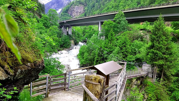
Figure 32: "Fellibrücke" hanging bridge
After approximately 2 hours they reached Gurtnellen and found at the entrance of the village a convenient site for their pick nick. It was very pleasant, as there were several trees and the "Reuss" river was spending a cool breeze on that hot day. As soon as everyone was refreshed and strengthened again, they continued hiking further to Wassen via "Pfaffensprung".
"Pfaffensprung" (Figure 33) is a ravine at Wassen and famous for its characteristic geo-biological nature and historic-cultural background. Here one can clearly see the creativeness of river water shaping a landscape.
_corr.jpg)
Figure 33: "Pfaffensprung" ravine
The influence of water has always played an important role in the landscape formation of the Canton Uri. The "Reuss" river has formed during thousands of years at "Pfaffensprung" a small ravine in the tough rocks. There also exist several myths at the site among the people of the region, one of which is that the people believed that a valuable treasure was hiding in an underground passage, however searches were to no avail (PFAFFENSPRUNG).
In this coarsely landscape, between Gurtnellen and Wassen, the railway line overcomes an altitude difference of around 200 meters. By means of the "Pfaffensprung" helical tunnel and two further turnaround tunnels at Wassen, built into the mountain north (Leggisteintunnel) and south (Wattinger Tunnel) of the village, the trains can gain in elevation throughout the entire trip (KEHRTUNNEL).
Close to the "Pfaffensprung" site they saw the "hydroelectric power station Wassen", where electricity has been produced since 1949 by hydropower. In 2015 the Swiss Federal Railways (SBB) became the main share holder (90%) and Wassen is therefore of great importance for the traction power supply for the SBB (WASSERKRAFT WASSEN).
Behind the hydroelectric power station their walk continued further direction to the village of Wassen. They first past the artificial lake, behind the lake they had a clear view on the up heaving little church of Wassen "Chileli Wassen". To reach the church their path went from the lake further through a dense ravine forest. It took them about 40min to reach the small village of Wassen, which has a population of approximately 400 inhabitants (WASSEN).

Figure 34: The Gallus-Church of Wassen
The "Chileli Wassen" (Figure 34) is a Gallus-Church and located on a prominent cliff edge overlooking the village. Ancient writings show that the church had already existed in the Middle Age, in 1480. It was for travelers an important direction guide on their difficult journey to the Gotthard pass. In the year 1734 the baroque church was rebuilt and still is an impressive edifice (KIRCHE WASSEN). Through the inauguration of the Gotthard railway line in the year 1882 the Gallus-Church of Wassen became world-famous and got to be an important landmark of the "Gotthard railway line". During the journey, the looping and turnaround effect causes the train to pass three times by Wassen, where a traveler sees the Gallus-Church each time from a new perspective (KIRCHE WASSEN; KEHRTUNNEL; WASSEN).
The last part of their hiking track took them on a smooth path high above the highway to Göschenen. There they crossed several waterfalls tumbling down with strong power into the "Reuss" river. The nature also presented itself as highly flexible and well adapted to the unstable conditions of the terrain, with meadows, pinewoods, shrubs, ferns, debris and rock vegetation. On their way they came across one of the "Kabelbude" (Figure 35), which are small houses and were used as important centers for the transmission of signals in the rail traffic in the older days (KABELBUDEN).

Figure 35: Cable booth "Kabelbude" used to be the center for transferring signals in the rail traffic
The village of Göschenen has currently a population of approximately 400 inhabitants. The small village is an excursion destination for people interested in the history and evolution of the Gotthard railway traffic, particularly the construction of the Gotthard tunnel
(Figure 36). Just across the railway station there is a show in one of the former survey adits (Visierstollen), which documents the construction from 1872 to 1882 and further 13 stations in the village highlight the most fascinating stories related to Göschenen as Gotthard Tunnel Village (GOESCHENEN).

Figure 36: Treno Gottardo entering the 15km long Gotthard tunnel in Göschenen
In Göschenen they collected their baggage from the railway station and headed to their overnight hotel "Zum Weissen Rössli" just 5min away. The hotel has a history that goes back to the year 1830 (HOTEL WEISSES RÖSSLI).
It had been a long day, so they were glad to have their dinner in the hotel and enjoyed the house specialty, "Poulet im Chörbli", where half a chicken is served together with a delicious homemade sauce and French fries. After dinner they retired early and satisfied to bed.