Day 11: Travel by train & bus to Rodi & walk to Faido. Travel by train to Lavorgo & walk to Giornico. Travel by bus & train to Bellinzona (MAPS 3 & 4).
After breakfast they headed to the railway station of Airolo (1141m a.s.l.), which is the highest railway station of the Swiss Federal Railways (SBB) (BAHNHOF AIROLO). There they boarded the "Treno Gottardo" to Faido. In Faido they changed to a bus and got off at Rodi "Dazio Grande".
The "Dazio Grande" is a building from the middle of the 16th century. It served as customs house for goods, transit traffic, hoarse-changing station, guesthouse, hostel and warehouse until 1803, the year when the Ticino became part of the Swiss Confederation. It remained in operation, until the Gotthard railway line was inaugurated in 1882. Nowadays, it is still open for the public as a museum and provides a rustic restaurant and overnight accommodation (DAZIO GRANDE).
From there they started their hiking, which took them along the "Via Gottardo Süd", passing by the two most impressive gorges ("Piottino" and "Biaschina"), which are shaping the landscape of the upper Ticino, and ending by the village Giornico.
Day 11: Travel by train & bus to Rodi & walk to Faido. Travel by train to Lavorgo & walk to Giornico. Travel by bus & train to Bellinzona (MAPS 3 & 4).
Day 8: Walk from Göschenen to Hospental via Andermatt (Map 3).
After breakfast, Daniela arranged with the reception to send their luggage to the hotel "St. Gotthard" in Hospental. Then they started their hiking.
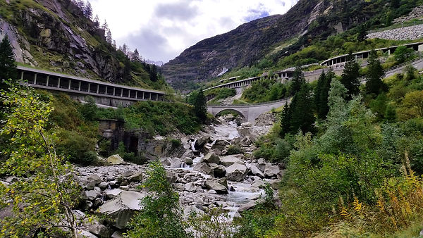
Figure 37: Hiking track along the "Schöllenenschlucht" ravine
The walk took them along the "Schöllenenschlucht" (Figure 37), which has been for a long time a major obstacle on the alpine crossing journey over the Gotthard pass from North to South. The ravine was only accessible for traffic in the year 1200 with the construction of the "Teufelsbrücke" bridge. A legend, handed down from early times, says that the constructor of the first bridge was the devil. From the years since 1230 the building of the bridge went through several obstructions until the new modern road bridge in 1955 could be finally realized. Nowadays an elegant modern road bridge arches over the former "Teufelsbrücke" (Figure 38), with a mural by the artist Heinrich Danioth, reminding of the scene legend of the devil and his bridge (SCHÖLLENENSCHLUCHT; Figure 39).

Figure 38: The former "Teufelsbrücke" bridge and the modern road bridge from 1955

Figure 39: Mural by Heinrich Danioth, showing the scene legend of the devil and his bridge
The major part of their path went fortunately along the sparkling water of the "Reuss" river, so it was always very refreshing on this hot day. After approximately an hour walk they found a small pick nick place, where they had a short break and enjoyed a marvelous view to the rocks surrounding the "Schöllenenschlucht". They continued their walk further direction to Andermatt and went over the old "Teufelsbrücke" bridge.

Figure 40: "Suworow" memorial
After crossing the bridge they passed by the "Suworow" memorial (Figure 40), which honors the Russian soldiers who got killed in the battle of the 25th September in 1799, when the Russian General Suworow fought against French forces at the "Teufelsbrücke" bridge (SCHÖLLENENSCHLUCHT). The next hiking path took them through the "Urnerloch" to the famous village-resort Andermatt (ANDERMATT).
The "Urnerloch" is a road tunnel and was built under the authority of the fortress engineer Morettini from the "Maggia" valley Ticino (SCHÖLLENENSCHLUCHT).
In Andermatt they went to the café "Baumann" for a refreshment. From there they continued further along the "Reuss" river through the wide landscape of the "Urseren" valley (Figure 41) up to Hospental.
The landscape of the "Urseren" valley has been shaped by the "Reuss" glacier and is composed of one main valley and several side valleys. The "Urseren" valley was during the time of first settlers rich in forest. The name "Urseren", which originates from the Latin word "Ursus", refers to a large existence of bears, who favor a dense forest. Due to avalanches and over-exploitation of wood for house construction and firewood there are not many forests left at present. Reforestation started too late, only in the second half of the 19th century. However, the unfavorable climate (vegetation period: 3-4 month) and environmental conditions (avalanches and further natural hazards) impede a continuous development of forest vegetation (URSERENTAL).

Figure 41: The "Urseren" valley above Hospental with view to the famous Tourist village-resort Andermatt
The hiking path to Hospental was more relaxing compared to the steep ascend through the "Schöllenenschlucht". On their left side they had a clear view to the peak (P. Centrale: 2999m a.s.l.) and on their right side to the peak (Mittagsstock: 2988m a.s.l.). Way in the back they could see the peak (Gross Furkahorn: 3167m a.s.l.).

Figure 42: The small village of Hospental
Approaching Hospental they were impressed by the large groups of small hills "humps" at the outcome of the Gotthard "Reuss" river side valley, which are an important evidence of glacial landscaping (URSERENTAL). They had a clear view to the road onto the Passo del San Gottardo (2106m a.s.l.), which they planned to explore the next day (Figure 42).
Hospental (Figure 43) is located in the heart of the Urseren valley, between Andermatt and Realp and has a population of barely 200 inhabitants. The political municipality of Hospental includes also the Walser settlement "Zumdorf", which is, with 4 permanent inhabitants, the smallest village in Switzerland.
Hospental was already populated in the middle age by the employees of the monastery Disentis GR. The impressive tower block
(Figure 44), which is visible from far away, is a remnant of medieval settlement. Between 1848 and 1882 Hospental was a very important place of custom check for the Gotthard postal traffic (Figure 43) with regular coach service from Flüelen over the Gotthard pass to Camerlata by Como in Italy (HOSPENTAL).

Figure 43: Gotthard postal traffic in Hospental, which is nowadays an important touristic attraction

Figure 44: Tower block in Hospental
In Hospental they went to the hotel "St. Gotthard" (Figure 45), a charming old building. The historic house was built by the local builder Bartholomäus Schmid in the year 1722. It belongs to one of the most representative baroque residential buildings in the "Urseren" valley.
In the year 1899 the house was transformed into a bed and breakfast under the name "Hotel St. Gotthard", which was an important over night place for mule-drivers and travelers on the way over the Gotthard pass (HOTEL ST. GOTTHARD).

Figure 45: Hotel "St. Gotthard"
After checking in, the group got ready for dinner, which was served on the terrace of the restaurant. They retired early to bed and looked forward to the next day's program.