Day 11: Travel by train & bus to Rodi & walk to Faido. Travel by train to Lavorgo & walk to Giornico. Travel by bus & train to Bellinzona (MAPS 3 & 4).
After breakfast they headed to the railway station of Airolo (1141m a.s.l.), which is the highest railway station of the Swiss Federal Railways (SBB) (BAHNHOF AIROLO). There they boarded the "Treno Gottardo" to Faido. In Faido they changed to a bus and got off at Rodi "Dazio Grande".
The "Dazio Grande" is a building from the middle of the 16th century. It served as customs house for goods, transit traffic, hoarse-changing station, guesthouse, hostel and warehouse until 1803, the year when the Ticino became part of the Swiss Confederation. It remained in operation, until the Gotthard railway line was inaugurated in 1882. Nowadays, it is still open for the public as a museum and provides a rustic restaurant and overnight accommodation (DAZIO GRANDE).
From there they started their hiking, which took them along the "Via Gottardo Süd", passing by the two most impressive gorges ("Piottino" and "Biaschina"), which are shaping the landscape of the upper Ticino, and ending by the village Giornico.
Day 11: Travel by train & bus to Rodi & walk to Faido. Travel by train to Lavorgo & walk to Giornico. Travel by bus & train to Bellinzona (MAPS 3 & 4).
Excursions using the S15 train line:
Figure 1: Additional information board about the "Ritterhaus" Bubikon

Figure 2: Additional information board about the "Egelsee" lake

Figure 3: Information board about the "Schwarzbach" waterfall

Figure 4: Additional information board about the "Mettmenhaslisee" lake

Figure 5: Additional information board about the "Lützelsee" lake
_corr2.jpg)
Figure 6: Additional information board about the drumlin landscapes "Zürcher Oberland"
_corr.jpg)
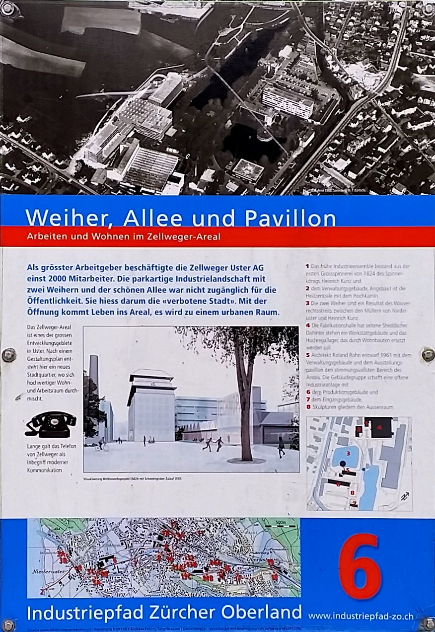
Figure 7: Additional information board about the "Zellwegerpark"

Figure 8: Additional information board about the "Zellwegerpark"

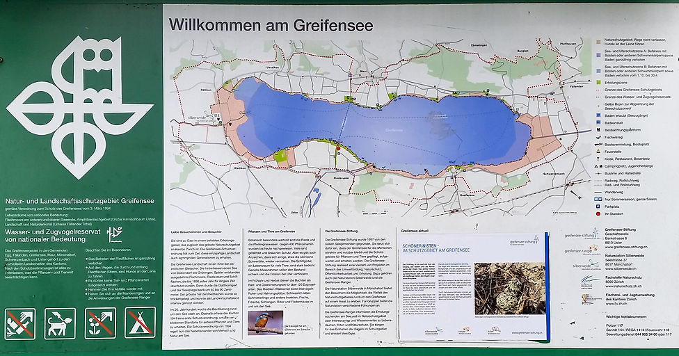
Figure 9: Additional information board about the "Greifensee" lake
_corr.jpg)
Figure 10: Additional information board about the "Pfäffikersee" lake, including the "Robenhauserriet" wetlands

Figure 11: Additional information board about the promontory "Hurden"

Figure 12: Additional information board about the nature reserve "Frauenwinkel"

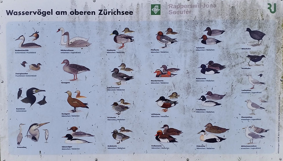
Figure 13: Information board about the water birds found in the "Zurich-Obersee" lake

Excursions using the Voralpen-Express and Treno Gottardo:
Figure 14: Additional information board about the "Klosterwald" forest in Einsiedeln

Figure 15: Additional information board about the forest use in the "Klosterwald" of Einsiedeln

Figure 16: Additional information board about the moorlands of "Rothenthurm"

Figure 17: Information board hotel "Rössli"

Figure 18: Additional information board about the landslide track of Goldau

Figure 19: Additional information board about the special forest reserve "Goldauer Bergsturz"

Figure 20: Additional information board about the "Lauerzersee-Sägel-Schutt" nature reserve

Figure 21: Additional information board about the "Goldseeli" lake

Figure 22: Additional information board about the wetland habitats found along the landslide track of Goldau

Figure 23: Additional information board about the "Weg der Schweiz" trail

Figure 24: Information board about the forest reserve "Rütliwald"

Figure 25: Map showing the forest reserve "Rütliwald" and typical plant species found in the "Rütliwald"

Figure 26: Additional information board about the "Rütli" site

Figure 27: Additional information board about the "Reussdelta" nature reserve

Figure 28: Additional information about the "Lorelei" islands in the "Reussdelta" nature reserve

Figure 29: Additional information board about the Gotthard transit axis

Figure 30: Additional information board about the construction of railway and road along the Gotthard line

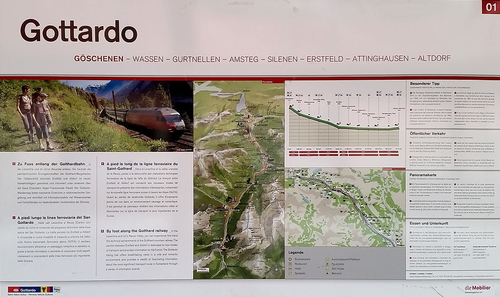
Figure 31: Additional information board about the "Gottardo" hiking track northern side

Figure 32: Additional information board about the "Gottardo" hiking track southern side

Figure 33: Additional information board about the "Intschitobel (Intschireuss)" bridge

Figure 34: Additional information board about the "Pfaffensprung" water catchment

Figure 35: Additional information board about the geological conditions in the middle "Reuss" valley

Figure 36: Additional information board about the helical tunnel system

Figure 37: Additional information board about the village of Wassen

Figure 38: Additional information board about the cable booth "Kabelbude"

Figure 39: Additional information board "Around the Gotthard Tunnel Village on Foot"

Figure 40: Additional information and references to the booklet "Around the Gotthard Tunnel Village on Foot"

Figure 41: Additional information about the Gotthard Tunnel construction

Figure 42: Additional information about the hotel "Weisses Rössli"

Figure 43: Additional information board about the "Teufelsbrücke" bridge

Figure 44: Picture showing the battle between Russian and French soldiers at the "Teufelsbrücke" bridge on the 25th of September in 1799


Figure 45: Information board about plant species growing on the Gotthard pass
Figure 46: Additional information board about the "Dazio Grande" building and the former mule track "strada urana" through the "Piottino" gorge

Figure 47: Additional information board about the former mule track "strada urana" through the "Piottino" gorge

Figure 48: Additional information board about the former and actual way of travel from North to South

Figure 49: Additional information board about the helical tunnel system through the "Piottino" gorge

Figure 50: Additional information board about hotels in Faido during the belle époque

Figure 51: Additional information board about the first electric installation "Lüs eletrica" in the Ticino in 1889, where electricity for light was produced by means of hydroelectric power from the water catchment area of the "Piumogna" waterfall

Figure 52: Additional information board about the landscape surrounding the "Leventina" valley in the region of Faido and the "Piumogna" waterfall

Figure 53: Additional information board about the helical tunnel system through the "Biaschina" gorge

Figure 54: Additional information board about the chestnut forest "La Selva castanile di Nivo" between Lavorgo and Chironico

Figure 55: Additional information about the castles of Bellinzona

Source: Newspaper "Hauseigentümer - Ausgabe Nr. 9 - 15. Mai 2021"
Figure 56: Additional information board about the nature reserve "Bolle di Magadino"

Figure 57: Information board about the "Parco della pace" park

Figure 58: Additional information board about the "San Francesco" church

Figure 59: Additional information board about the "Visconteo" castle

Figure 60: Additional information board about the cultivation of wine in the "Terreni alla Maggia" farm

Figure 61: Additional information board about foodstuff produced and sold in the "Terreni alla Maggia" farm

Geological overview of Switzerland:
Figure 62: The former supercontinent "Pangäa"

Source: Labhart (2001) "Geologie der Schweiz"
Figure 63: Chronology table of Geologicaly outlined in millions of years (Ma)

Source: Geologischer Atlas der Schweiz 1:25'000
Figure 64: Showing the Geological landscapes of Switzerland traversed through the train line S15, Voralpen-Express and Treno Gottardo

Source: Labhart (2001) "Geologie der Schweiz", map modified with Adobe Illustrator CS2
Figure 65: Geological profile of the Gotthard base tunnel

Source: www.alptransit.ch, profile modified with Paint.Net v4.2.16
Figure 66: Geological profile of the Ceneri base tunnel

Source: www.alptransit.ch, profile modified with Paint.Net v4.2.16