Day 11: Travel by train & bus to Rodi & walk to Faido. Travel by train to Lavorgo & walk to Giornico. Travel by bus & train to Bellinzona (MAPS 3 & 4).
After breakfast they headed to the railway station of Airolo (1141m a.s.l.), which is the highest railway station of the Swiss Federal Railways (SBB) (BAHNHOF AIROLO). There they boarded the "Treno Gottardo" to Faido. In Faido they changed to a bus and got off at Rodi "Dazio Grande".
The "Dazio Grande" is a building from the middle of the 16th century. It served as customs house for goods, transit traffic, hoarse-changing station, guesthouse, hostel and warehouse until 1803, the year when the Ticino became part of the Swiss Confederation. It remained in operation, until the Gotthard railway line was inaugurated in 1882. Nowadays, it is still open for the public as a museum and provides a rustic restaurant and overnight accommodation (DAZIO GRANDE).
From there they started their hiking, which took them along the "Via Gottardo Süd", passing by the two most impressive gorges ("Piottino" and "Biaschina"), which are shaping the landscape of the upper Ticino, and ending by the village Giornico.
Day 11: Travel by train & bus to Rodi & walk to Faido. Travel by train to Lavorgo & walk to Giornico. Travel by bus & train to Bellinzona (MAPS 3 & 4).
Day 7: Travel by train to Uster. Visit the "Greifensee" lake & walk to Seegräben.
Visit the "Juckerfarm" adventure farm & walk to Wetzikon via the "Robenhauserriet" wetlands.
Travel by train back to Rapperswil.
At 07:30, the group was ready on time to catch the early train to Uster, leaving Rapperswil at 07:44.
Uster is with a population of over 35'000 inhabitants the third biggest city in Canton Zurich. In spite of being a booming business center, the town has not lost its rural charm (USTER). From the railway station the party started their walk direction to the "Greifensee" lake. On the way they passed by the city park and could see the impressing castle (Uster Schloss), which is the land mark of the city (Figure 26).

Figure 26: "Usterschloss" castle
Their path took them further along the "Ustermer Aa" river direction to the "Greifensee" lake. On their way they passed by an area "Zellweger Park", a former industrial district, where also one of the first large spinning factory in Switzerland used to be found. Nowadays the area has been renatured and is besides a place for relaxing also popular for living (quiet and centralized)
(ZELLWEGERPARK; Figure 27).

Figure 27: "Zellweger Park" in Uster
They reached the "Greifensee" lake after a good half hour, where they went to the lido for a coffee and a short break. There they were impressed by the beauty of nature surrounding the lake (Figure 28). The "Greifensee" lake is with a surface of 8.45km2 the second largest lake in the Canton Zurich and a large part is a nature reserve (GREIFENSEE).

Figure 28: The beauty of nature along the "Greifensee" lake
An hour later they continued their walk to the small village of Seegräben. To reach Seegräben they had to walk back the same way as they came till the railway station. By the railway station they went through the pedestrian underpass. The walk to Seegräben took them first through the industrial area, followed by the settlement area and finally reaching the agricultural area of Uster. As soon as they reached the agricultural area, they were rewarded by a wonderful panoramic view to the Glarus Alps ("Vrenelisgärtli": 2905m a.s.l., "Clariden": 3267m a.s.l., "Tödi": 3614m a.s.l.), which made Nicolas again very happy. The Glarus Alps are a world heritage and famous for their notable fault in Alpine geology (GLARNER HAUPTÜBERSCHIEBUNG). Furthermore, they also could see some other peaks, such as, "Uri Rotstock" (2929m a.s.l.) and "Bristen" (3073m a.s.l.). Then, they continued to Seegräben through the dense brushwood of a broadleaved forest. Around noon they reached the charming village of Seegräben, which is famous for its adventure farm "Juckerfarm" specialized on organic products (JUCKERFARM; Figure 29).
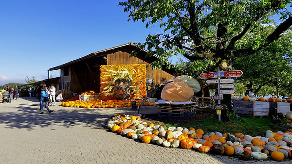
Figure 29: The "Juckerfarm" adventure farm where every autumn a great pumpkin exposition takes place
The "Juckerfarm" offers for visitors facilities to picnic. Daniela and Thomas decided to give the group a longer break.
After the visit to the farm they headed to the "Robenhauserried" wetlands, which is the silt area of the "Pfäffikersee" lake
(Figures 30 and 31). The landscape is a wide nature reserve and belongs to one of the most important wetlands of the Swiss midlands (ROBENHAUSERRIET).

Figure 30: "Robenhauserriet" wetlands

Figure 31: "Pfäffikersee" lake
From the lake site of the "Pfäffikersee" lake (Figure 31) they continued to the next stop, the town of Wetzikon, which is a booming commercial center in the "Zurich Oberland" and has a population of almost 25'000 inhabitants (WETZIKON). The walk to Wetzikon took approximately 40min, it went through fields and along small water streams, but as they came closer to the town they had to go unfortunately through the city traffic. Close to the railway station they decided to stop for a coffee at the "Café Janz" and wait for their train back to Rapperswil.
In Rapperswil, the group split up and agreed to meet at "Dieci's" restaurant around 18:30. After dinner, Thomas assembled the group and discussed the plan for the last day.