Day 11: Travel by train & bus to Rodi & walk to Faido. Travel by train to Lavorgo & walk to Giornico. Travel by bus & train to Bellinzona (MAPS 3 & 4).
After breakfast they headed to the railway station of Airolo (1141m a.s.l.), which is the highest railway station of the Swiss Federal Railways (SBB) (BAHNHOF AIROLO). There they boarded the "Treno Gottardo" to Faido. In Faido they changed to a bus and got off at Rodi "Dazio Grande".
The "Dazio Grande" is a building from the middle of the 16th century. It served as customs house for goods, transit traffic, hoarse-changing station, guesthouse, hostel and warehouse until 1803, the year when the Ticino became part of the Swiss Confederation. It remained in operation, until the Gotthard railway line was inaugurated in 1882. Nowadays, it is still open for the public as a museum and provides a rustic restaurant and overnight accommodation (DAZIO GRANDE).
From there they started their hiking, which took them along the "Via Gottardo Süd", passing by the two most impressive gorges ("Piottino" and "Biaschina"), which are shaping the landscape of the upper Ticino, and ending by the village Giornico.
Day 11: Travel by train & bus to Rodi & walk to Faido. Travel by train to Lavorgo & walk to Giornico. Travel by bus & train to Bellinzona (MAPS 3 & 4).

Figure 222: The castle complex in Pfäffikon SZ (previously called Weissenburg) dates back to the year 965. It is in close proximity to the lake of Zurich and near the railway station.


Figure 223: The bright early spring sun shining through the "Klosterwald" forest in Einsiedeln. On the right picture we can see a bunch of cowslip (Primula veris) growing on the forest ground

Figure 224: View to the monastery of Einsiedeln, through the still scarcely developed early spring forest of the "Klosterwald"

Figure 225: From the viewing point "Vogelhärd" (975m a.s.l.), we catch sight of the lush green meadows and the "Sihlsee" lake. Way in the back, are the still partly snow-covered peaks of the eastern-Central Swiss Alps

Figure 226: From the village Bennau direction to Einsiedeln, meadows in full bloom

Figure 227: The moorlands of Rothenthurm in spring with varied vegetation.
Details:
Left middle picture shows a patch of marsh marigold (Caltha palustris) growing in a hollow of the moorland.
Right middle picture a beautiful bouquet of troll flower (Trollius europaeus) growing in the fields.
Left lower picture cotton grass (Eriophorum angustifolium)
Right lower picture Polygonum bistorta

Figure 228: The village center of Rothenthurm with the "Letziturm" or red tower in the back, which was constructed in the year 1323 and gave Rothenthurm its name
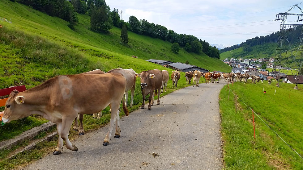
Figure 229: Herd of cows following me on my hiking tour in Rothenthurm

Figure 230: Near Biberegg (by Rothenthurm) sparkling clear water tumbling down from the "Steiner Aa" stream

Figure 231: Picture taken from the Voralpen-Express between Sattel and Steinerberg, cherry trees in full bloom

Figure 232: The Voralpen-Express shortly after Steinerberg, passing through a field of dandelion. Way in the back we can see the partly snow-covered peak of the "Rigi" mountain.

Figure 233: Hiking tour from "Rigi Staffel" (1604m a.s.l.) to the alp restaurant "Schild" (1431m a.s.l.), going through a 5.1km long thematic path (Botanic and Geology of the "Rigi" mountain).
Details:
Upper left picture: Troll flowers (Trollius europaeus), also called "Rigirolle" and view to the lake of Zug
Upper right picture: From the sight "Chänzeli" (1464m a.s.l.), view to the Lake of Lucerne and the city of Lucerne
Lower left picture: Reddish blossom of a mountain thistle (Carduus defloratus)
Lower right picture: Rocky path between "Rigi First" and alp restaurant "Schild", one can admire the characteristic conglomerate rocks of the "Rigi-Nagelfluh"

Figure 234: The "Schuttwald" forest Goldau with impressive rocks found along the forest track

Figure 235: I am walking around the "Goldseeli" lake and admiring its natural splendor

Figure 236: View from the Treno Gottardo to the "Rigi" mountain, shortly before a thunderstorm

Figure 237: Spring time in the harbor of Brunnen and the "Urnersee" lake.
Left picture shows happy mallard ducks looking forward to a refreshing swim.
Right picture an overwhelming view from the harbor of Brunnen to the Rütli up to the other end of the lake

Figure 238: The landing stage of "Rütli" in the spring time

Figure 239: Hiking track along the Axenstrasse from Flüelen to Sisikon. Spring awaking with the sprouting of leaves on the trees

Figure 240: The harbor of Flüelen preparing for the starting season of boat trips

Figure 241: Nature reserve "Reussdelta" and view to the snow-covered mountain peaks of the "Grosse Windgällen" (left) and "Bristen" (middle peak in the background)

Figure 242: Picture taken from the Treno Gottardo between Erstfeld and Amsteg, showing a pasture covered with striking white yarrow (Achillea millefolium)

Figure 243: The "Reuss" plain in the peak of spring.
Left picture shows the monastery of "St. Lazarus" in Seedorf.
Right picture a small wetland habitat near Seedorf.

Figure 244: Early spring in Amsteg, the peak of "Gross Windgällen" (3187m a.s.l.) is still snow-covered.
We can also see the "Chärstelenbachbrücke", which is with a length of 127m, the longest railway bridge of the Gotthard north ramp. Below the bridge we see the hydroelectric power station of Wassen, which belongs to the Swiss Federal Railways (SBB) and is important for the electrification of the Gotthard railway line.

Figure 245: Hiking track along the "Reuss" river between Gurtnellen and Amsteg.
On the right picture we can see lots of wild geranium (Geranium sylvaticum), which are frequently found in the shade of the trees

Figure 246: The village of Gurtnellen by the "Reuss" river which is bordered by fresh green riparian vegetation

Figure 247: Enjoying my picnic lunch in the midst of a high-growing meadow, between Gurtnellen and Wassen with view direction to the Gotthard region

Figure 248: Picture taken from the Treno Gottardo, showing the famous church of Wassen after the third rotation surrounded by the lush green meadows


Figure 249: Easter traffic on Good Friday 15th April 2022 on the north-south axis.
Upper picture is taken from the Treno Gottardo and shows the traffic jam on the northern side of the Alps (starting close to Erstfeld).
In contrast to the above situation, the lower picture shows an almost empty highway at the south portal, shortly after Airolo.
A German saying: "Der Kluge reist im Zuge", which means: "Smart people travel by train!"

Figure 250: Highway bridge traversing over the "Reuss" river between Wassen and Göschenen

Figure 251: The "Göschenerreuss" river passing through the village of Göschenen and view to the "Göschenertal" valley


Figure 252: Hiking tour from Airolo direction to the fortress "Motto Bartola" (1527m a.s.l.) along the mountain pass road, leading to the "Passo del San Gottardo"
Details:
Upper left picture: A bunch of orchids (Orchis mascula) growing along the pass road
Upper right picture: Magnified view of the orchids
Lower left picture: A sparse coniferous forest with a beautiful larch tree
Lower right picture: A field of dandelion close to the fortress

Figure 253: Hiking tour from Airolo to the small village of Nante (1429m a.s.l.).
Left picture: View from the hiking track direction to the "Passo del San Gottardo".
Right picture a bunch of Ajuga pyramidalis growing near the hiking track.

Figure 254: Along the hiking track from Airolo to Madrano, crocuses growing between the rocks, end of March

Figure 255: On the hiking track from Madrano to the "Valle Canaria" valley, we can see the effect of weather congestion, where Airolo is protected in the shadow of the mountains and therefore sunny and dry


Figure 256: On the hiking tour through the "Canaria" valley.
Upper picture shows the rippling fresh water from the "Canaria" river.
Lower pictures show a selection of plants growing on the forest ground, Polygala chamaebuxus (left picture) and Petasites albus (right picture)


Figure 257: Hiking track from Airolo to Brugnasco along the "Strada Alta", which is a 45km long elevated hike through the "Leventina" valley and flowers growing along the pass (crocuses and red forest carnation, Silene dioica)


Figure 258: Hiking tour from Piotta to Altanca. The hiking track goes parallel to the "Funicular Ritom", which is with a maximum gradient of 878 per mil one of the steepest cable cars in the world.

Figure 259: The village of Altanca (1390m a.s.l.), imbedded in a wonderful nature

Figure 260: In the early spring, view to the villages of Ambri and Piotta from the "Via Gottardo" hiking track direction to Rodi


Figure 261: Several hepatica flowers (left picture) along the hiking track from Ambri to Rodi , which are frequently found in forests and flower from March to Mai. On the right picture, an old tree stump, which looks like a small hut.

Figure 262: Walk along the Ticino river from Ambri to Quinto, during early spring vegetation develpment

Figure 263: View to the village of Quinto and the upper Leventina valley

Figure 264: Pre Easter greetings from a garden in the village center of Quinto

Figure 265: Lilies of the valley (Convallaria majalis) growing in May on the forest ground next to the hiking track between Ambri and Quinto

Figure 266: The "Laghetti Audan" are two small lakes near Ambri. Here one can fish, relax and enjoy a delicious meal at the "Grotto" restaurant

Figure 267: Hiking track between Faido and Chinchengo, passing through a forest. Leaves start to develop on the trees and birds are twittering a beautiful early morning concert

Figure 268: My companion, a fire salamander, on the hiking track between Faido and Chinchengo

Figure 269: On the hiking track along the "Ticino" river from Faido to the "Piumogna" waterfall, vegetation is still at its early stage after winter. Flowering white willow trees (Salix alba) with attractive catkins are predominant

Figure 270: Upper part of the "Piumogna" waterfall in Faido

Figure 271: Bright spring colors surrounding the "Piumogna" waterfall in Faido

Figure 272: Hiking tour from Faido to Primadengo (975m a.s.l.) through a light woodland of mixed deciduous and coniferous trees.
On the right picture we can see a bunch of Euphorbia cyparissias growing through the rocks.

Figure 273: Cat standing for photo shoot at the village square of Calpiogna (1144m a.s.l.) above Faido

Figure 274: Digitalis purpurea alba with its stunning growth type and wonderful blossoms, growing near the hiking track between Primadengo and Faido

Figure 275: On the hiking tour from Faido to the pretty village of Osco (1158m a.s.l.).
Left picture: Mixed deciduous and coniferous forest with a bunch of Phyteuma spicatum growing at the edge of the path
Right picture: A rich meadow area and the village of Osco in the back

Figure 276: View to the "Media Leventina" valley from the hiking track between Osco and Mairengo

Figure 277: Between Mairengo and Faido sweet woodland strawberries growing near the hiking track

Figure 278: Hiking tour from Faido to Fusnengo along the "Ticino" river, which reflects the bright green colors of the broad-leaved forest

Figure 279: The steep waterfall of the "Ri della Froda" in Fusnengo

Figure 280: The left picture shows the hiking track from Chiggiogna to Faido which passes along several waterfalls. On the right picture we can see the "Ri della Froda" waterfall through the forsythia bushes.

Figure 281: Crocuses blossoming on the hiking trail between Chiggiogna and Faido
Figure 282: Hiking track along the "Ticino" river between Nivo and Faido, passing by a mixed deciduous and coniferous forest with lots of birch trees

Figure 283: On the hiking track through the "Selva di Nivo" forest from Nivo to Chironico, several primroses reawakening from the winter sleep

Figure 284: Chestnut trees in their bright green elliptic serrated leaves growing on the track from Nivo to Chironico


Figure 286: Enjoying an ice cold footbath in the "Ticinetto" river in Chironico with view direction to the "Val Chironico" valley

Figure 287: Hiking along the "Ticino" river (left picture) at the lowest end of the "Leventina" valley, passing by the pretty little village of Personico (right picture)


Figure 288: The waterfall of "Santa Petronilla" (left picture) is the highest waterfall in the Ticino and one reaches it by an impressive chestnut forest with age-old chestnut trees (right picture)

Figure 289: On the hiking track direction to the "Montebello" castle one can admire several primroses growing between the rocks

Figure 290: The hills surrounding the "Montebello" and "Sasso Corbaro" castles in Bellinzona after a sudden snow fall beginning April

Figure 291: Flowering trees growing on the "Castelgrande" castle hill, in the back the snow covered peak of the "Pizzo di Claro", show spring awakening and saying goodbye winter!

Figure 292: View from the "Montebello" castle (left) to the "Sasso Corbaro" castle, which is immersed in beautiful fresh and green broad-leaved trees

Figure 293: The "Castelgrande" tower with its crenelled defense wall stands out in the brightness of spring sunshine

Figure 294: Wine yards growing along the "Castelgrande" defense wall in Bellinzona. In the back we see the "Magadino" plain

Figure 295: Stairway descend, starting from the "Castelgrande" castle to the "Piazza Collegiata"

Figure 296: Easter Saturday at the market of Bellinzona.
Left picture shows the ristorante "Peverelli" exhibiting Easter specialties.
Right picture shows the lively terrace of the restaurant.

Figure 297: Bellinzonas castles standing out in the fresh spring forest vegetation (April).
Left picture shows the "Sasso Corbaro".
Right picture shows the "Montebello" castle.

Figure 298: Hiking track to the "Sasso Corbaro" castle, traversing partly through a beautiful chestnut forest

Figure 299: Mother duck and her chicks on a discovery journey on the "Lago Maggiore" lake in Locarno

Figure 300: I am having a picnic by the harbor of Locarno with a curious lizard in my company

Figure 301: Impressive large trees growing on the lake promenade in Locarno direction to the Lido


Figure 302: The lake promenade in Locarno direction to the Lido with magnolias and other amazing spring plants.
The lower pictures show two very special plants, looking like heads of lettuce.

Figure 303: Magnolia petals covering the grass at the lake promenade in Locarno direction to Minusio

Figure 304: The "Parco delle Camelie" park in Locarno is next to the "Parco della Pace" and one can enjoy the beauty of Camellia flowers almost throughout the year, starting at the end of March.

Figure 305: A selection of Camelias growing in the "Parco delle Camelie" end of March, from top left to bottom right: Apollo, Brushfields Yellow, Francofurtensis, Cloisonne, Commander Mulroy and Isabella Spinola

Figure 306: At the beach adjoining the "Parco delle Camelie" parc. View to the "Bolle di Magadino" nature reserve and the partly snow-covered peaks of the Southern Alps

Figure 307: Hiking tour along the "Sentiero Collina Alta" path, from the "Madonna del Sasso" church down to the lake in Minusio, with a fantastic view to the "Lago Maggiore" lake

Figure 308: Hiking path along the "Sentiero di Navegna" in Minusio, which starts from the lake shore and leads to a marvelous ravine forest

Figure 309: Butterfly sunbathing on the beach in Minusio

Figure 310: A wild cherry tree in bloom by the Madonna del Sasso church above Locarno

Figure 311: Enjoying a walk from the Monte della Trinità (395m a.s.l.) down to Locarno, on a rainy day in May. In German we say: "Maienregen bringt den Segen", which means: "May rain brings blessings".
Left picture shows sweet smelling jasmine flowers growing along a stone fence.
Right picture: Agave growing out of the wall and other lovely exotic plants.

Figure 312: Hiking track from "Monte della Trinita" to Solduno. It goes through a dozen of steps, through a marvelous spring vegetation and one is rewarded by a unique view to Ascona with the "Lago Maggiore" lake in the back

Figure 313: Walking along the "Maggia" river with its surrounding spring vegetation

Figure 314: Hiking track from Arcegno (388m a.s.l.) to Monte Verità (332m a.s.l.) passing through a beautiful oak mixed forest in its bright spring

Figure 315: Along the track between Arcegno and Monte Verità lots of carved wood sculptures are found from several artists.
Here a selection of some impressive sculptures from top left to bottom right by: Willy Guglhör (Ascona), Simon Sonognini (Sonogno), Raphael Pache (Matran) and Mauro Antonietti (Calonico)

Figure 316: The Monte Verità (332m a.s.l.) is a peaceful area. There is a hotel, a conference center for knowledge sharing in scientific research and a large park full of exotic plants, among others a tea plantation made up of 1400 plants.
Left picture shows the tea plantation, which is made according to Japanese tradition.
Right picture shows the tea plant "Camellia sinensis", whose leaves provide the raw material for green, black, white, yellow, post-fermented and oolong tea.

Figure 317: The lakeside of Ascona is slowly reawakening after winter