Day 11: Travel by train & bus to Rodi & walk to Faido. Travel by train to Lavorgo & walk to Giornico. Travel by bus & train to Bellinzona (MAPS 3 & 4).
After breakfast they headed to the railway station of Airolo (1141m a.s.l.), which is the highest railway station of the Swiss Federal Railways (SBB) (BAHNHOF AIROLO). There they boarded the "Treno Gottardo" to Faido. In Faido they changed to a bus and got off at Rodi "Dazio Grande".
The "Dazio Grande" is a building from the middle of the 16th century. It served as customs house for goods, transit traffic, hoarse-changing station, guesthouse, hostel and warehouse until 1803, the year when the Ticino became part of the Swiss Confederation. It remained in operation, until the Gotthard railway line was inaugurated in 1882. Nowadays, it is still open for the public as a museum and provides a rustic restaurant and overnight accommodation (DAZIO GRANDE).
From there they started their hiking, which took them along the "Via Gottardo Süd", passing by the two most impressive gorges ("Piottino" and "Biaschina"), which are shaping the landscape of the upper Ticino, and ending by the village Giornico.
Day 11: Travel by train & bus to Rodi & walk to Faido. Travel by train to Lavorgo & walk to Giornico. Travel by bus & train to Bellinzona (MAPS 3 & 4).
Autumn season:
Additional information board about the autumn market of Regensberg

Additional information board about the "Heilig Hüsli" chapel in Rapperswil

Additional information board about the "Red Tower" in Rothenthurm

Additional information board about the "Depotweg" trail near the railway station of Arth-Goldau


Additional information board about a limestone rock near Axenstein, which has been shaped by aboveground karst processes

Additional information board about the "Meierturm" tower in Silenen; https://silenen.ch/tourismus/brauchtum-historisches/historische-bauten/turm-der-edlen-freiherren-von-silenen

Additional information board about the "Telldenkmal" memorial in Altdorf

Additional information board about the "Axenstrasse en miniature" near Attinghausen

Additional information board about the "Burgruine" medieval fortress in Attinghausen

Additional information board about the maintenance and intervention centre of the "Gotthard" base tunnel

Additional information board about the NRLA intermediate construction site of the "Gotthard" base tunnel

Additional information board about the "Bitzi" nature reserve in Silenen

Additional information board about the location "Pfaffensprung" in Wassen; see more under: https://www.maerchenstiftung.ch/maerchendatenbank/3907/pfaffensprung

Additional information board about the "Ponte Vecchio" bridge in Camorino near Giubiasco

Additional information board about the "Fortini della Fame" (famine fortresses) in Camorino near Giubiasco

Additional information board about the recuperated chestnut forest "Selva castanile Casnotta" in the community of Monteceneri

Additional information board about the village of Viona

Additional information board about the Viewpoint of Tendrasca

Additional information board about the village of Mondacce

Additional information board about the "Olive Grove" trail from Lugano to Gandria; see also under:https://www.luganoregion.com/en/theme-trail/details/58645146


Advent season:
Additional information board about the winter hiking trail from Göschenen to Abfrutt

Additional information board, which I had found by a Christmas tree, which had been decorated by the playgroup "Rägebogä" in the woods between Rothenthurm and Biberegg

Winter season:
Additional information board about the forest reservat "Lägern"

Additional information board about the castle ruin "Altlägern"

Additional information board about the tunnel, which was build for the "Arth-Rigi-Bahn" railway in 1875

Additional information board about the "Gesslerburg" castle ruin in Küssnacht am Rigi

Additional information board about the "Wyler-Brücke" wooden bridge in Brunnen

Additional information board about the fen and amphibian spawning area "Klosterried" near Brunnen


Additional information board about the snowshoe trail "Andermatt-Mettlen-Mariahilfkapelle" in Andermatt

Additional information board about the Brunnen-Morschach-Axenstein railway, which was inaugurated in the year 1903 and ceased in the year 1969

Additional information board about the history of vine cultivation in Bürglen (Canton Uri)

Additional information board about the community of Faido, which comprises 13 small villages

Additional information board about the "giocafaido" quiz path in Faido

Additional information board about the formation of the "Monte Ceneri" moutain, see more information under https://laviadelceneri.ch/.
See also information about the cultural-didactical trail "Via del Ceneri" path under the following link: https://www.bellinzonaevalli.ch/de/itineraries/details/La-Via-del-Ceneri/148160.html

Additional information board about the fortifications found in the surroundings of the "Monte Ceneri" mountain

Additional information board about the "Strada del Montecenerino" (also known as "strada romana") historical traffic route

Additional information board about the problems and solutions in maintaining the historical traffic route "Strada del Montecenerino"


Additional information board about the chestnut forest "Pontiva", which was ecologically upgraded by the Alptransit Gotthard AG

Additional information board about the "Percorsovitea" path and the history of wine cultivation in the surroundings of Gordola

Additional information board about the "Sentiero delle rive" path from Gordola to Tenero

Additional information board about the "Sentiero Roccabella" path from Mondacce to Minusio

Additional information board about the "Capèla Rota" broken chapel near Brione

Additional information board about the "El pont del Sipp" roman bridge near Brione

Additional information board about the pollination mechanism of azalea in the "San Grato" park in Carona; for more information see: https://parcosangrato.ch/de/

Additional information board about the "Piazza Don Gottardo Zurini" in Tegna

Spring season:
Additional information board about the insights one gets to see in nature reserve "Mettmenhaslisee" in Niederhasli from the observation tower

Additional information board about the oldest spinning building in Uster from the year 1816, which is found along an educational trail, giving information about the industrial history in the Zurich Oberland. After 1995, the building got transformed into space for backery, business and living; see more: https://www.ipzo.ch/; https://m.zuerioberland-tourismus.ch/de/industriepfad; https://www.uster.ch/sehenswuerdigkeiten/1547

Additional information board about the "Dampflok-Remise" in Uster, which is the oldest depot for steam locomotive in Switzerland

Additional information board about the industrialization in Wändhüslen, near Bubikon, in 1871

Additional information board about the settlement of Barenberg in Bubikon

Additional information board about the 2,5km long circular trail near Jona, where one can see several scenes of nature

Additional information board about the landscape development in the region of Rapperswil-Jona, canton St. Gallen


Additional information board about the "Galgenchappeli" location between Altberg and Einsiedeln. The location was used until the year 1840, as a place of refuge for sinners from the criminal court of Einsiedeln

Additional information board about the ancient track of the landslide event in Goldau from the year 1806

Additional information board about the forest reservat "Goldauer Bergsturzgebiet"; see more under: https://www.sz.ch/public/upload/assets/65750/Tafelgross.pdf

Additional information board about the "Gasthaus Bauernhof" building in Goldau

Additional information board about the "Lauerzersee" lake

Additional information about the quarry "Zingel" at the foot of the Urmiberg mountain in Seewen: https://www.kibag.ch/de/baustoffe/zingel-steinbruch-und-naturpark.html
Additional information board about the "Auenspur" in the estuary of the "Steiner Aa" stream

Additional information board about the "pin oak" tree in Brunnen, which was created as climate oasis


Additional information board the renatured streambed of the "Waldbrunnen" stream

Additional information board about the railway village of Erstfeld

Additional information board about the start of the Gotthard mountain track, shortly after Erstfeld

Additional information board about the "Eligius" chapel in the hamlet Ried, near Amsteg

Additional information board about the "Meitschlingen" bridge, where the old mule track beginns with an ascend towards Gurtnellen

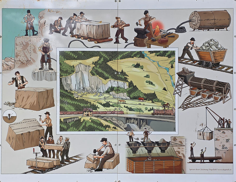
Additional information board about the procedure of quarrying in Wassen during the 19th Century; see more under https://www.museen-uri.ch/museen/freilichtmuseum-steinbruch-antonini
Additional information board about the helical tunnel system in Wassen


Additional information board about the Ritom power station in Piotta

Additional information board about the funicular Ritom and the "Alpe Piora" hiking region

Additional information board about the memorial of the drill head from the tunnel drilling machine (TCM), which was used to construct the "Gotthard" base tunnel

%20'Heidi'%20.jpg)
Additional information board about the history of the "Mulino del Precassino" mill above Cadenazzo

Additional information board about the technique of the "Mulino del Precassino" mill above Cadenazzo and technical data to the mill wheel


Additional information board about the environment and surroundings of the "Mulino del Precassino" mill above Cadenazzo

Additional information board about the "Montecenerino" path. Along the path there are some larger stones, showing small depressions with shapes of bowls or crosses. Those stones, known as "sacrifice stones", are mostly found in areas with a scenic importance, such as, viewpoints and other high trafficated areas. They served as an important good-luck charm for the journey during the past centuries.

Example of a stone with a bowl depression that I found near the "Monte Ceneri" pass. The bowl depresssion is marked with a red square

Additional information board about the "Ca' di Ferro" building in Minusio

Additional information board about the evolution and nature found on the "Caslano" mountain, near Lugano; see also under: https://www.caslano.ch/EN-Il-Monte-Caslano

Additional information board about the museum of fossils from Monte San Giorgio UNESCO World Heritage Site, in Meride; see also under: https://www.museodeifossili.ch/index.html

Additional information board about the Turkish temple of Parco Scherrer in Morcote and the Gaspare Fossati

Additional information board about the Lemon House of Parco Scherrer in Morcote and the artist Renzo Fontana

Additional information board about the nature protection zone "Alpe Vicania" above Morcote

Summer season:
Additional information board about the meagre meadows "Schmidhalden" between Steinmaur and Regensberg, which are under nature protection

Additional information board about the "Tägernau" pond, which is also known as "Brändliweier" pond and the "Braendlin" spinning factory


Additional information board about the "Schaugarten" flower beds in Pfäffikon SZ, which gives ideas how one's own garden can be arraged

Additional information board about the battle of Morgarten (Canton Schwyz and Zug) (15th of November 1315). The battle belongs to the first Swiss freedom battle

Additional information board about the "Platz der Auslandschweizer" place of Swiss citizen living abroad

Additional information board about the recuperated chestnut groven "Chilenwald" in Brunnen; see also under: https://pfarrei-ingenbohl.ch/chilenwald/

Additional information board about the nature reserve "Hopfräben" at the estuary of the "Muota" river near Brunnen; see also under: https://www.erlebnisregion-mythen.ch/de/erlebnisse/sommer/naturerlebnisse/naturschutzgebiet-hopfraeben-brunnen/

Additional information board about the hiking track in the "Muotatal" valley with jokes "Witz-Wanderweg"

A poem at the "Gruebi Tannen" picnic place
%20Picknickplatz_corr.jpg)
Additional information board about the "Zwing Uri" ruin between Amsteg and Silenen; https://uri.swiss/oeffentliche-einrichtung/zwing-uri

Additional information board about the bad weather in Gurtnellen in August 1987

Additional information board about the multiple use of "Reuss" river water from the hydro power stations of KW Göschenen, KW Wassen and KW Amsteg

Additional information board about the origin of the location name "Pfaffensprung" by Wassen

Additional information board about the "Häderlisbrücke" bridge above Göschenen

Additional information board about the tower "Turm von Hospental" of the medieval castle ruin from the 13th Century

Additional information board about the material logistics, from the construction of second tunnel tube at the "Gotthard" road tunnel in Airolo; see more under: https://gotthardtunnel.ch/

Recuperated chestnut forest in Personico "Selva castanile di Personico", lower "Leventina" valley

Additional information board about the "Gàisc" biotope near Bodio; see also under https://www.pronatura-ti.ch/it/Gaisc

Additional information board about the "Santa Petronilla" cultural trail.
First picture: chestnut forests between Biasca and the "Santa Petronilla" waterfall
Second picture: The importance of Biasca, as transit place, on the north-south axis
Lowest picture: The historic church in Biasca of the saints "Pietro" and "Paolo"


Additional information board about the "Ponte Tibetano" hanging bridge near Bellinzona
